1
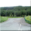
The end of the road and bus route, Maerdy
Boulders mark the end of Wrgant Place. This is the northern edge of residential Maerdy, the village at the top end of the Rhondda Fach valley. The bus shelter is at Maerdy Terminus, http://www.geograph.org.uk/photo/2411659 served by buses to and from a wide range of locations including Porth, Pontypridd and Cardiff.
Image: © Jaggery
Taken: 11 May 2011
0.03 miles
2
Springfield Road, Maerdy
Houses near the northern edge of the village, and the northern edge of houses in the Rhondda Fach valley.
Image: © Jaggery
Taken: 11 May 2011
0.03 miles
3
Springfield Road
Image: © Colin Pyle
Taken: 4 Jan 2010
0.05 miles
4
Main entrance to Avon factory, Maerdy
Located at the southern edge of the Avon Engineered Rubber Ltd factory, which occupies the site of the former Mardy Colliery.
Image: © Jaggery
Taken: 11 May 2011
0.07 miles
5
Wood Street
Image: © Colin Pyle
Taken: 4 Jan 2010
0.07 miles
6
Maerdy bus terminus
Maerdy Terminus is a solitary bus shelter in a turning loop on Wrgant Place, opposite Springfield Road. The sign alongside the shelter shows that the terminus is served by a surprisingly wide range of destinations for village with a population of about 3,500 - Royal Glamorgan Hospital; Porth, Pontypridd and Cardiff; Tonypandy and Clydach Vale; Ystrad Rhondda Railway Station.
Image: © Jaggery
Taken: 11 May 2011
0.09 miles
7
Park Place houses, Maerdy
Houses at the northern end of Park Place, viewed from the edge of Maerdy Park paddling pool. http://www.geograph.org.uk/photo/2411842
Image: © Jaggery
Taken: 11 May 2011
0.09 miles
8
Springfield Road bus terminus.
Image: © Colin Pyle
Taken: 4 Jan 2010
0.10 miles
9
Maerdy Park Paddling Pool
Viewed from Park Place. The pool was drained at the date of this photo, early May.
Image: © Jaggery
Taken: 11 May 2011
0.11 miles
10
Top (western) end of Wood Street, Maerdy
Aptly-named Wood Street ends at the edge of woodland.
Image: © Jaggery
Taken: 11 May 2011
0.11 miles


