IMAGES TAKEN NEAR TO
Pen Tyntyla, FERNDALE, CF43 3RE
Introduction
This page details the photographs taken nearby to Pen Tyntyla, CF43 3RE by members of the Geograph project.
The Geograph project started in 2005 with the aim of publishing, organising and preserving representative images for every square kilometre of Great Britain, Ireland and the Isle of Man.

There are currently over 7.5m images from over14,400 individuals and you can help contribute to the project by visiting https://www.geograph.org.uk
Image Map
Images are licensed for reuse under creativecommons.org/licenses/by-sa/2.0
Notes
- Clicking on the map will re-center to the selected point.
- The higher the marker number, the further away the image location is from the centre of the postcode.
Image Listing (43 Images Found)
Images are licensed for reuse under creativecommons.org/licenses/by-sa/2.0
Image
Details
Distance
1
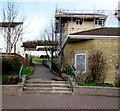
Steps to a path past Penrhys Uniting Church
The church http://www.geograph.org.uk/photo/4428510 is on the right.
Image: © Jaggery
Taken: 30 Mar 2015
0.05 miles
2
Llanfair Penrhys
The village of Penrhys that exists today was developed from 1966 as a new council housing estate.
Though a church had been promised, none was built. Worshippers included a small group who gathered in the disused shop of the Community Centre and a few Pentecostalists who met in a flat.
Llanfair Penrhys or Penrhys Uniting Church opened in 1992, the culmination of ecumenical effort to serve an isolated hilltop community with few shops, few recreational facilities and high unemployment.
Image: © Jaggery
Taken: 30 Mar 2015
0.06 miles
3
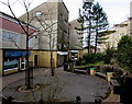
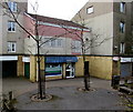
Y Ffynon Centre, Penrhys
In the centre of the village.
Woody's general store and post office http://www.geograph.org.uk/photo/4428466 on the left,
Penrhys Partnership office http://www.geograph.org.uk/photo/4428483 in the middle distance.
Image: © Jaggery
Taken: 30 Mar 2015
0.06 miles
4
Penrhys Partnership office, Penrhys
The office is in the Y Ffynon Centre. The Penrhys Partnership website states that the Penrhys Partnership has been at the forefront of community empowerment over the last twenty-two years providing a range of programmes and priorities to address the imbalance in today’s socially excluded society.
Image: © Jaggery
Taken: 30 Mar 2015
0.06 miles
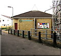
5
Woody's general store and post office, Y Ffynon Centre, Penrhys
In late March 2015, there is nothing on the exterior of Woody's general store
to show that it contains a post office counter, so I was surprised to find that
it is shown on the Post Office's website branch finder in April 2015.
Image: © Jaggery
Taken: 30 Mar 2015
0.08 miles
6
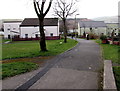
Penrhys footpath
Between houses in Heol Mair and Heol Ioan.
Image: © Jaggery
Taken: 30 Mar 2015
0.08 miles
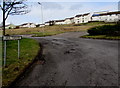
7
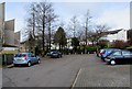
Parking area at the northern end of Heol Ioan, Penrhys
Near the Penrhys Village Centre. http://www.geograph.org.uk/photo/4428441
Image: © Jaggery
Taken: 30 Mar 2015
0.08 miles
8
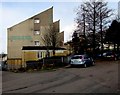
Penrhys Village Centre
On the west side of Heol Ioan, Penrhys. A doctors' surgery is on the right side of the Centre.
Image: © Jaggery
Taken: 30 Mar 2015
0.09 miles
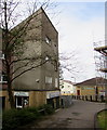
9
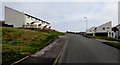
Heol-y-Waun houses, Penrhys
At a height of 330 metres (1,080 ft) above sea level. One local website describes Penrhys as
"set on a hillside where it seems to rain horizontally".
I was fortunate to visit the village on a fine day!
Image: © Jaggery
Taken: 30 Mar 2015
0.09 miles
10
Heol y Ffynon houses in Penrhys
Looking NNW from Heol Teifionydd.
Image: © Jaggery
Taken: 30 Mar 2015
0.11 miles