IMAGES TAKEN NEAR TO
Heol Pendyrus, FERNDALE, CF43 3PG
Introduction
This page details the photographs taken nearby to Heol Pendyrus, CF43 3PG by members of the Geograph project.
The Geograph project started in 2005 with the aim of publishing, organising and preserving representative images for every square kilometre of Great Britain, Ireland and the Isle of Man.

There are currently over 7.5m images from over14,400 individuals and you can help contribute to the project by visiting https://www.geograph.org.uk
Image Map
Images are licensed for reuse under creativecommons.org/licenses/by-sa/2.0
Notes
- Clicking on the map will re-center to the selected point.
- The higher the marker number, the further away the image location is from the centre of the postcode.
Image Listing (45 Images Found)
Images are licensed for reuse under creativecommons.org/licenses/by-sa/2.0
Image
Details
Distance
1
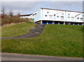
Steps up from Heol Pendyrus, Penrhys
To houses facing Penrhys Primary School.
Image: © Jaggery
Taken: 30 Mar 2015
0.01 miles
2
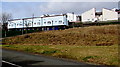
Houses above Heol Pendyrus, Penrhys
In the NE part of residential Penrhys.
Image: © Jaggery
Taken: 30 Mar 2015
0.02 miles
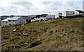
3
Base of a demolished building in Penrhys
Viewed across Heol Pendyrus in the NE part of the village
where there are many bases and other remnants of demolished buildings.
Image: © Jaggery
Taken: 30 Mar 2015
0.03 miles
4
Heol-y-waun houses in Penrhys
Viewed from an area formerly occupied by houses in the NE of Penrhys.
Image: © Jaggery
Taken: 30 Mar 2015
0.04 miles
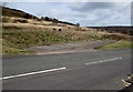
5
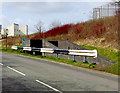
Black and white barrier at the edge of Heol Pendyrus, Penrhys
Extending for 25 metres between the road and a path http://www.geograph.org.uk/photo/4599696 descending to an underpass.
Image: © Jaggery
Taken: 30 Mar 2015
0.04 miles
6
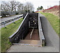
Path to an underpass beneath Heol Pendyrus, Penrhys
The underpass is to Penrhys Primary School.
Image: © Jaggery
Taken: 30 Mar 2015
0.04 miles
7
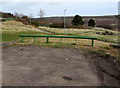
Green barrier across Heol-y-Waun, Penrhys
The eastern end of the road.
Image: © Jaggery
Taken: 30 Mar 2015
0.05 miles
8
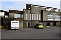
The Penrhys pub, Penrhys
Pub accessed by road from Heol Pen-y-Bryn. Walkers can also use steps up from Heol Pendyrus. http://www.geograph.org.uk/photo/4426201
Image: © Jaggery
Taken: 30 Mar 2015
0.05 miles
9
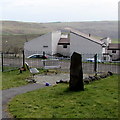
Benches at the eastern end of The Green Community Garden, Penrhys
A plaque on the rock records that The Green Community Garden was opened in March 2006.
Image: © Jaggery
Taken: 30 Mar 2015
0.05 miles
10
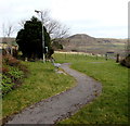
Path through The Green Community Garden, Penrhys
On the north side of the street named Heol-y-Waun.
Image: © Jaggery
Taken: 30 Mar 2015
0.05 miles