
IMAGES TAKEN NEAR TO
Park View, FERNDALE, CF43 3HL
Introduction
This page details the photographs taken nearby to Park View, CF43 3HL by members of the Geograph project.
The Geograph project started in 2005 with the aim of publishing, organising and preserving representative images for every square kilometre of Great Britain, Ireland and the Isle of Man.

There are currently over 7.5m images from over14,400 individuals and you can help contribute to the project by visiting https://www.geograph.org.uk
Image Map
Images are licensed for reuse under creativecommons.org/licenses/by-sa/2.0
Notes
- Clicking on the map will re-center to the selected point.
- The higher the marker number, the further away the image location is from the centre of the postcode.
Image Listing (86 Images Found)
Images are licensed for reuse under creativecommons.org/licenses/by-sa/2.0
Image
Details
Distance
1
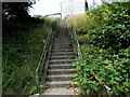
Steps up to Park View, Tylorstown
The steps, near the end of a path from Stanleytown, give a direct route up to Park View.
Those unable or unwilling to use the steps can take the longer path route to Park View.
Image: © Jaggery
Taken: 8 Aug 2013
0.01 miles

3

Tylorstown Primary School
Viewed across Edmund Street from the elevated pavement. http://www.geograph.org.uk/photo/3605956
Image: © Jaggery
Taken: 8 Aug 2013
0.03 miles
4
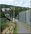
Footbridge over the Rhondda Fach, Tylorstown
The river footbridge carries a path from Stanleytown to Tylorstown.
Image: © Jaggery
Taken: 8 Aug 2013
0.03 miles
5

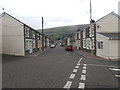
SW end of Edmund Street, Tylorstown
Edmund Street descends away from the A4233 East Road.
Image: © Jaggery
Taken: 20 Aug 2013
0.03 miles
6
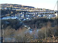
Rhondda Fach valley and footbridge, with Tylorstown beyond.
Image: © Colin Pyle
Taken: 4 Jan 2010
0.03 miles
8
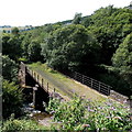
Former railway bridge over the Rhondda Fach, Tylorstown
Viewed from this http://www.geograph.org.uk/photo/3605769 footbridge.
The bridge formerly carried a railway. Passenger services in the area ceased in the 1960s.
Image: © Jaggery
Taken: 8 Aug 2013
0.05 miles
9
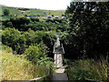
River footbridge, Tylorstown
Viewed from steps. http://www.geograph.org.uk/photo/3605793 The footbridge carries a path to Stanleytown over the Rhondda Fach river.
Image: © Jaggery
Taken: 8 Aug 2013
0.06 miles
10
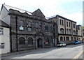
An interesting juxtapostion in Tylorstown
Side by side alongside the A4233 East Road are Tylorstown Conservative Club on the left
and Tylorstown Working Men's Club and Institute on the right.
Image: © Jaggery
Taken: 20 Aug 2013
0.06 miles