IMAGES TAKEN NEAR TO
Llanwonno Road, FERNDALE, CF43 3HA
Introduction
This page details the photographs taken nearby to Llanwonno Road, CF43 3HA by members of the Geograph project.
The Geograph project started in 2005 with the aim of publishing, organising and preserving representative images for every square kilometre of Great Britain, Ireland and the Isle of Man.

There are currently over 7.5m images from over14,400 individuals and you can help contribute to the project by visiting https://www.geograph.org.uk
Image Map
Images are licensed for reuse under creativecommons.org/licenses/by-sa/2.0
Notes
- Clicking on the map will re-center to the selected point.
- The higher the marker number, the further away the image location is from the centre of the postcode.
Image Listing (86 Images Found)
Images are licensed for reuse under creativecommons.org/licenses/by-sa/2.0
Image
Details
Distance
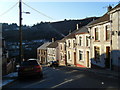
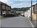
2
Llanwonno Road Stanleytown
Llanwonno Road climbs towards the centre of Stanleytown.
Image: © Jaggery
Taken: 8 Aug 2013
0.01 miles
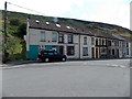
3
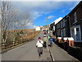
Stanleytown
Cerddwyr yn mynd i lawr y waered yn Stanelytown.
Walkers descending a hill in Stanleytown.
Image: © Alan Richards
Taken: 5 Mar 2016
0.01 miles
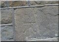
4
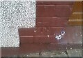
Ordnance Survey Cut Mark
This OS cut mark can be found on No26 Llanwonno Road. It marks a point 181.155m above mean sea level.
Image: © Adrian Dust
Taken: 3 Mar 2021
0.02 miles
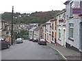
5
Down Llanwonno Road, Stanleytown
Llanwonno Road descends away from the centre of Stanleytown.
Image: © Jaggery
Taken: 8 Aug 2013
0.02 miles
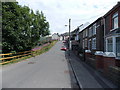
6
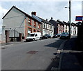
Llanwonno Road houses, Stanleytown
On this side, there are houses alongside only a 50 metre long part
of Llanwonno Road, whereas houses extend for 120 metres along the camera side.
Image: © Jaggery
Taken: 8 Aug 2013
0.02 miles
7
Witherdene Road, Stanleytown
Viewed from the corner of Llanwonno Road. Almost all the Witherdene Road houses are on this side. The solitary house on the opposite side is next to a children's playground.
Image: © Jaggery
Taken: 8 Aug 2013
0.03 miles
9
Ordnance Survey Cut Mark
This OS cut mark can be found on No3 Llanwonno Road. It marks a point 167.274m above mean sea level.
Image: © Adrian Dust
Taken: 3 Mar 2021
0.04 miles
10
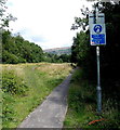
Cycle route north of Llanwonno Road bridge, Stanleytown
Viewed from the north side of this http://www.geograph.org.uk/photo/3598923 bridge. Distances shown along National Cycle Network
route 881 are 3 (miles) to Maerdy, 1¼ to Ferndale and ¼ to Tylorstown.
Image: © Jaggery
Taken: 8 Aug 2013
0.05 miles