IMAGES TAKEN NEAR TO
Stanley Square, FERNDALE, CF43 3ER
Introduction
This page details the photographs taken nearby to Stanley Square, CF43 3ER by members of the Geograph project.
The Geograph project started in 2005 with the aim of publishing, organising and preserving representative images for every square kilometre of Great Britain, Ireland and the Isle of Man.

There are currently over 7.5m images from over14,400 individuals and you can help contribute to the project by visiting https://www.geograph.org.uk
Image Map
Images are licensed for reuse under creativecommons.org/licenses/by-sa/2.0
Notes
- Clicking on the map will re-center to the selected point.
- The higher the marker number, the further away the image location is from the centre of the postcode.
Image Listing (95 Images Found)
Images are licensed for reuse under creativecommons.org/licenses/by-sa/2.0
Image
Details
Distance
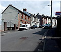
2
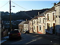
Stanley Square, Stanleytown
Question: Where does a square have only 1 side?
Answer: Here in Stanleytown. The name sign shows Stanley Square, which is 30 metres long, between Middle Terrace on this side and Lower Terrace ahead. There are 3 houses in Stanley Square, all in view.
Image: © Jaggery
Taken: 8 Aug 2013
0.01 miles
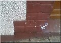
4
Ordnance Survey Pivot
This OS pivot can be found on the window sill of No1 Middle Terrace. It marks a point 188.400m above mean sea level.
Image: © Adrian Dust
Taken: 3 Mar 2021
0.01 miles
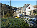
5
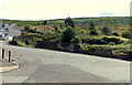
Remains of a building, Stanleytown
The remains are between Llanwonno Road and Upper Terrace. There were formerly quarries and tips nearby, so it is likely the building was in industrial use.
Image: © Jaggery
Taken: 8 Aug 2013
0.03 miles
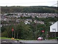
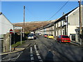
6
Long wall and railings in Stanleytown
The 40 metre long wall and railings on the left extend from
the corner of Middle Terrace to the corner of Upper Terrace ahead.
Image: © Jaggery
Taken: 8 Aug 2013
0.04 miles
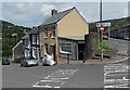
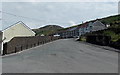
8
Llanwonno Road houses, Stanleytown
On this side, there are houses alongside only a 50 metre long part
of Llanwonno Road, whereas houses extend for 120 metres along the camera side.
Image: © Jaggery
Taken: 8 Aug 2013
0.05 miles
9
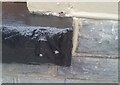
Ordnance Survey Cut Mark
This OS cut mark can be found on No26 Llanwonno Road. It marks a point 181.155m above mean sea level.
Image: © Adrian Dust
Taken: 3 Mar 2021
0.05 miles