IMAGES TAKEN NEAR TO
CF4 2BZ
Introduction
This page details the photographs taken nearby to CF4 2BZ by members of the Geograph project.
The Geograph project started in 2005 with the aim of publishing, organising and preserving representative images for every square kilometre of Great Britain, Ireland and the Isle of Man.

There are currently over 7.5m images from over14,400 individuals and you can help contribute to the project by visiting https://www.geograph.org.uk
Image Map
Images are licensed for reuse under creativecommons.org/licenses/by-sa/2.0
Notes
- Clicking on the map will re-center to the selected point.
- The higher the marker number, the further away the image location is from the centre of the postcode.
Image Listing (49 Images Found)
Images are licensed for reuse under creativecommons.org/licenses/by-sa/2.0
Image
Details
Distance
1
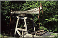
Melingriffith waterwheel powered pump
This had been very derelict and required a total rebuild. I don't much like the machine cut wood though.
Image: © Chris Allen
Taken: 23 May 2004
0.15 miles
2
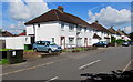
White houses and a telecoms cabinet, Heol Chappell, Whitchurch, Cardiff
From the corner of Westbourne Road.
Image: © Jaggery
Taken: 10 Aug 2017
0.15 miles
3
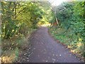
Taff Trail/NCN 8 route between Llandaff and Forest Farm
This section runs between the river and the Melingriffith housing estate. It can get quite busy at popular times as it is used by walkers, cyclists, and dog owners!
Image: © John Light
Taken: 10 Oct 2009
0.16 miles
4
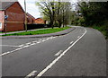
Bend in Ty Mawr Road, Llandaff North, Cardiff
The left turn is into the cul-de-sac Clos Ystum Taf. http://www.geograph.org.uk/photo/4920271
Image: © Jaggery
Taken: 18 Apr 2016
0.17 miles
5
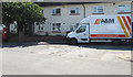
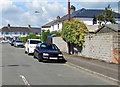
A&M Insulation vehicle, Westbourne Road, Whitchurch, Cardiff
A&M Insulation's business is cavity wall insulation and loft insulation.
Image: © Jaggery
Taken: 10 Aug 2017
0.17 miles
6
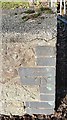
Ordnance Survey Cut Mark
This OS cut mark can be found on the wall NW side of Velindre Road. It marks a point 37.094m above mean sea level.
Image: © Adrian Dust
Taken: 18 Nov 2018
0.17 miles
8
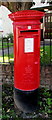
Queen Elizabeth II pillarbox detail, Westbourne Road, Whitchurch, Cardiff
Located here. http://www.geograph.org.uk/photo/5492917
Image: © Jaggery
Taken: 10 Aug 2017
0.18 miles
9
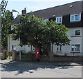
Queen Elizabeth II pillarbox, Westbourne Road, Whitchurch, Cardiff
Near Plasmelin Flats. http://www.geograph.org.uk/photo/5492918 to a closer view.
Image: © Jaggery
Taken: 10 Aug 2017
0.18 miles
10
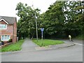
West along Heol Mathew, Whitchurch, Cardiff
From Heol Don along Heol Mathew towards Heol Chappell.
Image: © Jaggery
Taken: 10 Aug 2017
0.18 miles