1
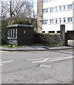
Dark green cabinet near Station Road, Treorchy
Located between Station Road and the Rhondda River, the cabinet is a Western Power Distribution electricity substation. Its identifier is TREORCHY S/S 542072
Image: © Jaggery
Taken: 6 Mar 2020
0.01 miles
2
Rhondda Pride 2019 mural, Treorchy
Located alongside the unnamed road from Station Road to Treorchy Co-op viewed in March 2020.
Dated 13-9-2019, the mural was created by Ruby Jones and Lucy Higgins.
Image: © Jaggery
Taken: 6 Mar 2020
0.01 miles
3
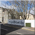
#Visittreorchy
On the wall between telecoms cabinet number 7 and the A4061 Station Road junction viewed in March 2020.
A mural https://www.geograph.org.uk/photo/6406867 is out of shot on the right side of the cabinet.
Image: © Jaggery
Taken: 6 Mar 2020
0.01 miles
4
Roadside boulders, Treorchy
Alongside the unnamed road from Station Road to Co-op Treorchy https://www.geograph.org.uk/photo/6406900 the boulders
prevent vehicles parking on a concrete area on the south bank of the Rhondda River.
Image: © Jaggery
Taken: 6 Mar 2020
0.01 miles
5
Rhondda Fawr, Treorchy
The river flows SE away from Station Road bridge.
Image: © Jaggery
Taken: 23 Jan 2012
0.02 miles
6
Grade II (star) listed Park and Dare Workmen's Institute, Treorchy
Located on the corner of Station Road and Dyfodwg Street. Erected in 1892 as a Workmen's Institute, paid for by the miners of Parc & Dare Collieries. Grade II (star) listed in 1996. Now a theatre.
Image: © Jaggery
Taken: 23 Jan 2012
0.02 miles
7
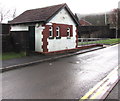
Former public toilets near Treorchy Library
Viewed in March 2020. The old toilets building has been replaced by recently-built toilets https://www.geograph.org.uk/photo/6414960 near the camera.
Image: © Jaggery
Taken: 14 Mar 2020
0.02 miles
8
Co-op name and direction sign, Station Road, Treorchy
Turn right ahead for the Co-op. https://www.geograph.org.uk/photo/6406900
Image: © Jaggery
Taken: 6 Mar 2020
0.02 miles
9
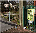
Family Funfair poster, Treorchy
The yellow poster on display on March 6th 2020 shows that the funfair is being
held in the Oval Car Park Treorchy from Thursday March 5th to Sunday March 8th.
Image: © Jaggery
Taken: 6 Mar 2020
0.02 miles
10
Downstream along Nant Cwm-parc, Treorchy
Nant Cwm-parc flows away from the camera towards its confluence with the Rhondda River.
Image: © Jaggery
Taken: 14 Mar 2020
0.02 miles


