IMAGES TAKEN NEAR TO
Holbrook Close, TREORCHY, CF42 6TJ
Introduction
This page details the photographs taken nearby to Holbrook Close, CF42 6TJ by members of the Geograph project.
The Geograph project started in 2005 with the aim of publishing, organising and preserving representative images for every square kilometre of Great Britain, Ireland and the Isle of Man.

There are currently over 7.5m images from over14,400 individuals and you can help contribute to the project by visiting https://www.geograph.org.uk
Image Map
Images are licensed for reuse under creativecommons.org/licenses/by-sa/2.0
Notes
- Clicking on the map will re-center to the selected point.
- The higher the marker number, the further away the image location is from the centre of the postcode.
Image Listing (122 Images Found)
Images are licensed for reuse under creativecommons.org/licenses/by-sa/2.0
Image
Details
Distance
1
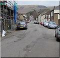
Up Cemetery Road, Treorchy
Cemetery Road ascends from the A4061 Bute Street towards Treorchy Cemetery
which opened in 1871, the first secular cemetery in the Rhondda valleys.
Image: © Jaggery
Taken: 9 Apr 2018
0.04 miles
2
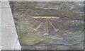
Ordnance Survey Cut Mark
This OS cut mark can be found on No7 Cemetery Road. It marks a point 170.804m above mean sea level.
Image: © Adrian Dust
Taken: 28 Apr 2017
0.05 miles
3
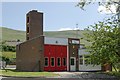
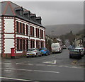
Treorchy Fire Station
Treorchy Fire Station, Bute Street, Treorchy lies up a side road from the main road along the valley through Treorchy
Image: © Kevin Hale
Taken: 5 Jun 2007
0.09 miles
4
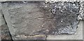
Ordnance Survey Cut Mark
This OS cut mark can be found on No87 Stuart Street. It marks a point 168.268m above mean sea level.
Image: © Adrian Dust
Taken: 28 Apr 2017
0.10 miles
5
Cemetery Road, Treorchy
From the north side of the A4061 Bute Street, Cemetery Road
leads to Treorchy Cemetery about 500 metres from the camera.
The Cardiff Arms https://www.geograph.org.uk/photo/6416815 is on the left.
Image: © Jaggery
Taken: 14 Mar 2020
0.11 miles
6
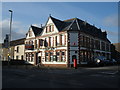
The Cardiff Arms, Bute Street, Treorchy
Image: © Roger Cornfoot
Taken: 14 Mar 2009
0.11 miles
7
Jobcentre Plus in Treorchy
Located in Oldway House, set back from the east side of the A4061 Bute Street.
The car park is for the vehicles of Jobcentre Plus staff only.
Image: © Jaggery
Taken: 9 Apr 2018
0.12 miles
8
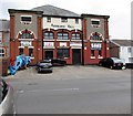
Abergorki Hall, Bute Street, Treorchy
The year 1915 is inscribed on the building, below ABERGORKI HALL. Built as Abergorki Workingmen's Institute, the construction was paid for by a levy paid by the workers of the Abergorky Colliery in Treorchy. There was a cinema in the building from the 1930s until the early 1970s, with c500 seats.
Now (April 2018) used as a community hall. Names on banners include Ystradyfodwg Art Society, Shin-gi-tai aikido, Traditional Korean karate.
Image: © Jaggery
Taken: 9 Apr 2018
0.12 miles
9
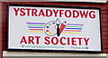
Ystradyfodwg Art Society name sign, Treorchy
On the wall of Abergorki Hall. https://www.geograph.org.uk/photo/5737926
Image: © Jaggery
Taken: 14 Mar 2020
0.12 miles
10
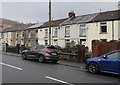
Bute Street houses, Treorchy
Alongside the A4061 Bute Street. The house on the right is near Abergorki Hall. https://www.geograph.org.uk/photo/5737926
Image: © Jaggery
Taken: 14 Mar 2020
0.12 miles