1
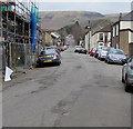
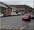
Up Cemetery Road, Treorchy
Cemetery Road ascends from the A4061 Bute Street towards Treorchy Cemetery
which opened in 1871, the first secular cemetery in the Rhondda valleys.
Image: © Jaggery
Taken: 9 Apr 2018
0.04 miles
2
Ordnance Survey Cut Mark
This OS cut mark can be found on No7 Cemetery Road. It marks a point 170.804m above mean sea level.
Image: © Adrian Dust
Taken: 28 Apr 2017
0.05 miles
3
The Cardiff Arms, Bute Street, Treorchy
Image: © Roger Cornfoot
Taken: 14 Mar 2009
0.07 miles
4
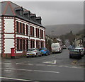
Cemetery Road, Treorchy
From the north side of the A4061 Bute Street, Cemetery Road
leads to Treorchy Cemetery about 500 metres from the camera.
The Cardiff Arms https://www.geograph.org.uk/photo/6416815 is on the left.
Image: © Jaggery
Taken: 14 Mar 2020
0.07 miles
5
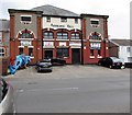
Abergorki Hall, Bute Street, Treorchy
The year 1915 is inscribed on the building, below ABERGORKI HALL. Built as Abergorki Workingmen's Institute, the construction was paid for by a levy paid by the workers of the Abergorky Colliery in Treorchy. There was a cinema in the building from the 1930s until the early 1970s, with c500 seats.
Now (April 2018) used as a community hall. Names on banners include Ystradyfodwg Art Society, Shin-gi-tai aikido, Traditional Korean karate.
Image: © Jaggery
Taken: 9 Apr 2018
0.08 miles
6
Ystradyfodwg Art Society name sign, Treorchy
On the wall of Abergorki Hall. https://www.geograph.org.uk/photo/5737926
Image: © Jaggery
Taken: 14 Mar 2020
0.08 miles
7
Ordnance Survey Cut Mark
This OS cut mark can be found on No87 Stuart Street. It marks a point 168.268m above mean sea level.
Image: © Adrian Dust
Taken: 28 Apr 2017
0.08 miles
8
Treorchy Fire Station
Treorchy Fire Station, Bute Street, Treorchy lies up a side road from the main road along the valley through Treorchy
Image: © Kevin Hale
Taken: 5 Jun 2007
0.09 miles
9
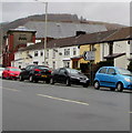
On-street parking, Bute Street, Treorchy
Pointing towards Crichton Street, a sign shows Abergorci Ind(ustrial) Est(ate) and its Welsh equivalent.
Image: © Jaggery
Taken: 14 Mar 2020
0.09 miles
10
NW along the A4061 Bute Street, Treorchy
Ahead for Ynyswen and Treherbert. The Flamingo https://www.geograph.org.uk/photo/6413573 is in the background.
Image: © Jaggery
Taken: 14 Mar 2020
0.09 miles


