IMAGES TAKEN NEAR TO
Glyncoli Close, TREORCHY, CF42 6SU

Introduction

This page details the photographs taken nearby to Glyncoli Close, CF42 6SU by members of the Geograph project.

The Geograph project started in 2005 with the aim of publishing, organising and preserving representative images for every square kilometre of Great Britain, Ireland and the Isle of Man.

There are currently over 7.5m images from over14,400 individuals and you can help contribute to the project by visiting https://www.geograph.org.uk

Image Map


Images are licensed for reuse under creativecommons.org/licenses/by-sa/2.0
Notes
  • Clicking on the map will re-center to the selected point.
  • The higher the marker number, the further away the image location is from the centre of the postcode.

Image Listing (65 Images Found)

Images are licensed for reuse under creativecommons.org/licenses/by-sa/2.0
  • ...
Image
Details
Distance
1
Ordnance Survey Cut Mark
This OS cut mark can be found on No37 Stuart Street. It marks a point 167.037m above mean sea level.
Image: © Adrian Dust Taken: 28 Apr 2017
0.14 miles
2
Ordnance Survey Flush Bracket (S1301)
This OS Flush Bracket can be found on the SW face of the school. It marks a point 167.660m above mean sea level.
Image: © Adrian Dust Taken: 28 Apr 2017
0.15 miles
3
Glyncoli Road, Treorchy
A view to the NE along Glyncoli Road from the corner of Dumfries Street on the left and Horeb Street on the right. Glyn Villa is on the right.
Image: © Jaggery Taken: 23 Jan 2012
0.16 miles
4
Western side of Treorchy Primary School
Viewed across Glyncoli Road. There is a Treorchy Male Choir blue plaque http://www.geograph.org.uk/photo/2790534 on the wall, below the school's name.
Image: © Jaggery Taken: 23 Jan 2012
0.16 miles
5
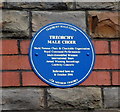
Treorchy Male Choir blue plaque in the wall of Treorchy Primary School
The plaque records that Treorchy Male Choir reformed here http://www.geograph.org.uk/photo/2790526 on October 16th 1946.
Image: © Jaggery Taken: 23 Jan 2012
0.16 miles
6
Houses on the west side of Glyncoli Road, Treorchy
Viewed from the edge of Treorchy Primary School. http://www.geograph.org.uk/photo/2790526
Image: © Jaggery Taken: 23 Jan 2012
0.16 miles
7
Treorchy Cemetery
Towards the eastern boundary of Treorchy Cemetery.
Image: © Alan Hughes Taken: 14 Dec 2020
0.17 miles
8
Ordnance Survey Cut Mark
This OS cut mark can be found on No87 Stuart Street. It marks a point 168.268m above mean sea level.
Image: © Adrian Dust Taken: 28 Apr 2017
0.18 miles
9
Luton Street, Treorchy
Looking to the northeast along Luton Street across Bute Street from the corner of Herbert Street.
Image: © Jaggery Taken: 14 Mar 2020
0.18 miles
10
Treorchy view
Taken from Tyn Y Bedw country walk and looking below you can see the town of Treorchy nestling between the hills.
Image: © Derek Cummings Taken: 14 Feb 2010
0.19 miles
  • ...