IMAGES TAKEN NEAR TO
Glyncoli Road, TREORCHY, CF42 6RY
Introduction
This page details the photographs taken nearby to Glyncoli Road, CF42 6RY by members of the Geograph project.
The Geograph project started in 2005 with the aim of publishing, organising and preserving representative images for every square kilometre of Great Britain, Ireland and the Isle of Man.

There are currently over 7.5m images from over14,400 individuals and you can help contribute to the project by visiting https://www.geograph.org.uk
Image Map
Images are licensed for reuse under creativecommons.org/licenses/by-sa/2.0
Notes
- Clicking on the map will re-center to the selected point.
- The higher the marker number, the further away the image location is from the centre of the postcode.
Image Listing (196 Images Found)
Images are licensed for reuse under creativecommons.org/licenses/by-sa/2.0
Image
Details
Distance
1
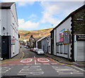
NE along Glyncoli Road, Treorchy
Viewed across the A4061. The 30mph speed limit drops to 20mph.
An old enamel sign showing HIGH STREET is on the wall on the right.
Image: © Jaggery
Taken: 6 Mar 2020
0.01 miles
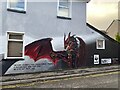
3
Mural on the wall of the Red Lion
Mural created by the pupils of Ysgol Gynradd Ynyswen.
Image: © Alan Hughes
Taken: 11 Dec 2023
0.02 miles
4
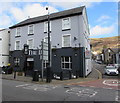
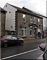
The Lion, Treorchy
Pub at 102 Bute Street on the corner of Glyncoli Road viewed in March 2020.
The building looked very different in January 2012 when the name on the wall was Lion Inn https://www.geograph.org.uk/photo/2790655
Image: © Jaggery
Taken: 6 Mar 2020
0.03 miles
5
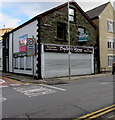
Former Bailey's Home shop, High Street, Treorchy
In March 2020 a board showing ENTIRE BUILDING TO LET is on the
High Street side of the shuttered shop on the corner of Glyncoli Road.
An old-style enamel sign showing HIGH STREET is on the wall near the corner.
Image: © Jaggery
Taken: 6 Mar 2020
0.03 miles
6
Barclays, 94 Bute Street, Treorchy
Bank branch viewed across the A4061 in March 2020.
Image: © Jaggery
Taken: 14 Mar 2020
0.03 miles
7
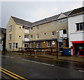
Pinewood House, High Street, Treorchy
Cwm Taf University Health Board building viewed across the A4061.
Image: © Jaggery
Taken: 14 Mar 2020
0.03 miles
8
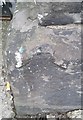
Ordnance Survey Rivet
This OS rivet can be found on the Bank, Bute Street. It marks a point 161.864m above mean sea level.
Image: © Adrian Dust
Taken: 28 Apr 2017
0.03 miles
9
Former church on a Treorchy corner
This is the Howard Street side of the former St Tyfodwg's Church dating from 1895.
In 2020 the building is a Superdrug health and beauty shop, entrance from Bute Street.
Image: © Jaggery
Taken: 6 Mar 2020
0.03 miles
10
Howard Street, Treorchy
From River Terrace along Howard Street towards Bute Street.
Image: © Jaggery
Taken: 6 Mar 2020
0.04 miles