1
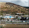
High Street, Treorchy
View along High Street, Treorchy, with Mynydd yr Eglwys in the distance.
Image: © Alan Hughes
Taken: 30 Oct 2017
0.05 miles
2
Ordnance Survey Cut Mark
This OS cut mark can be found on No55 High Street. It marks a point 157.545m above mean sea level.
Image: © Adrian Dust
Taken: 7 May 2017
0.06 miles
3
Treorchy & Cwmparc Boys & Girls Club, Treorchy
In a corrugated metal building on the south bank of the Rhondda River.
Image: © Jaggery
Taken: 6 Mar 2020
0.10 miles
4
Bethlehem Chapel, Treorchy
Non-conformist Calvinist Methodist chapel in Treorchy, built in 1881.
Image: © Alan Hughes
Taken: 30 Oct 2017
0.10 miles
5
Treorchy & Cwmparc Boys & Girls Club name sign, Treorchy
On this https://www.geograph.org.uk/photo/6406967 building.
Image: © Jaggery
Taken: 6 Mar 2020
0.10 miles
6
The Co-operative Foodstore and a hillside background, Treorchy
Set back from Station Road, the Co-operative Foodstore is on the right.
Image: © Jaggery
Taken: 4 Apr 2014
0.11 miles
7
Ordnance Survey Cut Mark
This OS cut mark can be found on No65 Prospect Place. It marks a point 163.205m above mean sea level.
Image: © Adrian Dust
Taken: 7 May 2017
0.12 miles
8
Welcome to Treorchy's Co-op
Set back 100 metres from the A4061 Station Road, this Co-op is on the south bank of the Rhondda River.
Image: © Jaggery
Taken: 6 Mar 2020
0.12 miles
9
Nant Cwm-parc towards the Rhondda River, Treorchy
The stream Nant Cwm-parc flows towards its confluence with the Rhondda River on the right.
Image: © Jaggery
Taken: 6 Mar 2020
0.12 miles
10
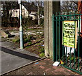
Family Funfair poster, Treorchy
The yellow poster on display on March 6th 2020 shows that the funfair is being
held in the Oval Car Park Treorchy from Thursday March 5th to Sunday March 8th.
Image: © Jaggery
Taken: 6 Mar 2020
0.13 miles


