IMAGES TAKEN NEAR TO
Church Street, TREORCHY, CF42 6NB
Introduction
This page details the photographs taken nearby to Church Street, CF42 6NB by members of the Geograph project.
The Geograph project started in 2005 with the aim of publishing, organising and preserving representative images for every square kilometre of Great Britain, Ireland and the Isle of Man.

There are currently over 7.5m images from over14,400 individuals and you can help contribute to the project by visiting https://www.geograph.org.uk
Image Map
Images are licensed for reuse under creativecommons.org/licenses/by-sa/2.0
Notes
- Clicking on the map will re-center to the selected point.
- The higher the marker number, the further away the image location is from the centre of the postcode.
Image Listing (78 Images Found)
Images are licensed for reuse under creativecommons.org/licenses/by-sa/2.0
Image
Details
Distance
1
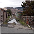
Puddles on a lane in Cwmparc
A large puddle and many small puddles are on the lane on the east
side of Church Street, between Vicarage Terrace and Tallis Street.
Image: © Jaggery
Taken: 4 Apr 2014
0.01 miles
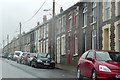
3
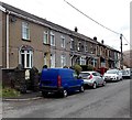
Houses at the eastern end of Vicarage Terrace, Cwmparc
Viewed from the corner of Church Street.
Image: © Jaggery
Taken: 4 Apr 2014
0.03 miles
4
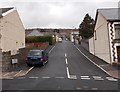
Church Street, Cwmparc
Church Street climbs away from Park Road towards Tallis Street.
Image: © Jaggery
Taken: 4 Apr 2014
0.04 miles
5
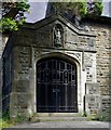
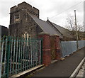
St George is Locked In
St Georges Church, Tallis Street, Cwm Pac, Treochy's South West facing porch.
'St George' watching the approaches from above the locked bar gated porch?
Image: © D M Wilmot
Taken: 28 Aug 2017
0.05 miles
7
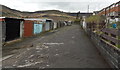
Lockup garages in Cwmparc
In the lane on the west side of Church Street, between Vicarage Terrace and Tallis Street.
Image: © Jaggery
Taken: 4 Apr 2014
0.05 miles
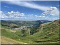
8
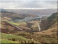
Vicarage Terrace, Cwmparc
There is this typical terraced housing in the south-east corner of the square, the highest road in the village of Cwmparc. Beyond is mountain moorland and forestry.
Image: © Graham Horn
Taken: 4 Oct 2008
0.05 miles
9
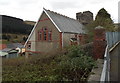
St George's Church Hall, Cwmparc
The hall is set below Tallis Street, on the east side of the church tower. http://www.geograph.org.uk/photo/4125256
Image: © Jaggery
Taken: 4 Apr 2014
0.06 miles
10
East side of St George's Church, Cwmparc
Viewed from Tallis Street looking towards the large square tower in the SE corner of the church.
Built on a hillside in the 1890s, St George is part of the Church in Wales parish of Pen Rhondda Fawr in the Diocese of Llandaff. http://www.geograph.org.uk/photo/4125240 to a view of the north side.
Image: © Jaggery
Taken: 4 Apr 2014
0.06 miles