IMAGES TAKEN NEAR TO
Ynyswen Road, TREORCHY, CF42 6ED
Introduction
This page details the photographs taken nearby to Ynyswen Road, CF42 6ED by members of the Geograph project.
The Geograph project started in 2005 with the aim of publishing, organising and preserving representative images for every square kilometre of Great Britain, Ireland and the Isle of Man.

There are currently over 7.5m images from over14,400 individuals and you can help contribute to the project by visiting https://www.geograph.org.uk
Image Map
Images are licensed for reuse under creativecommons.org/licenses/by-sa/2.0
Notes
- Clicking on the map will re-center to the selected point.
- The higher the marker number, the further away the image location is from the centre of the postcode.
Image Listing (133 Images Found)
Images are licensed for reuse under creativecommons.org/licenses/by-sa/2.0
Image
Details
Distance
1
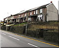
Row of houses above Ynyswen Road, Ynyswen
Above the A4061 Ynyswen Road, the main road through the village.
Image: © Jaggery
Taken: 21 Nov 2017
0.02 miles
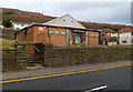
2
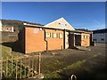
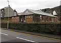
Ynyswen Welfare Hall
Miners’ Welfare Hall, Ynyswen.
Image: © Alan Hughes
Taken: 9 Jan 2019
0.02 miles
3
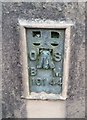
Ordnance Survey Cut Mark
This OS cut mark can be found on the SW angle of the Chapel wall. It marks a point 175.553m above mean sea level.
Image: © Adrian Dust
Taken: 28 Apr 2017
0.02 miles
4
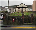
King George VI postbox in an Ynyswen Road wall, Ynyswen
The steps lead up to a long-derelict former Methodist church.
Image: © Jaggery
Taken: 21 Nov 2017
0.02 miles
5
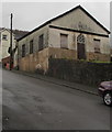
Ynyswen Welfare Hall, Ynyswen
Viewed across the A4061 Ynyswen Road, the main road through the village.
Formerly Ynyswen Miner's Welfare Hall, the building was erected in 1959
on the site of the first hall dating from 1933. Uses of the hall in 2017 include
OAP Activities •Indoor Bowls (men & women) •Dogs Club •Dancing classes (adult & junior) •Line dancing.
Image: © Jaggery
Taken: 21 Nov 2017
0.03 miles
6
Ordnance Survey Flush Bracket (10144)
This OS Flush Bracket can be found on the SW angle of the Chapel. It marks a point 178.528m above mean sea level.
Image: © Adrian Dust
Taken: 28 Apr 2017
0.03 miles
7
Former Methodist Church, Mace Lane, Ynyswen
In November 2017 mould is well established on the walls of the long-derelict former church erected in 1876.
Image: © Jaggery
Taken: 21 Nov 2017
0.03 miles
8
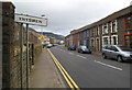
Western boundary of Ynyswen
Ynyswen Road (A4061) reaches Ynyswen, a village in the community of Treorchy, in the county borough of Rhondda Cynon Taf.
Image: © Jaggery
Taken: 23 Jan 2012
0.03 miles
9
Ynyswen Welfare Hall
A community centre set back from the north side of the A4061.
Image: © Jaggery
Taken: 23 Jan 2012
0.03 miles
10
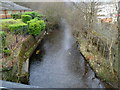
Rhondda Fawr river flows towards a road bridge near the A4061, Ynyswen
Viewed from the bridge at the northern end of the unnamed road from the A4061 to Ynyswen railway station. Ynyswen Clinic http://www.geograph.org.uk/photo/2785680 is on the left.
Image: © Jaggery
Taken: 23 Jan 2012
0.03 miles