IMAGES TAKEN NEAR TO
Kenry Street, TREORCHY, CF42 6DR
Introduction
This page details the photographs taken nearby to Kenry Street, CF42 6DR by members of the Geograph project.
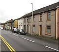
The Geograph project started in 2005 with the aim of publishing, organising and preserving representative images for every square kilometre of Great Britain, Ireland and the Isle of Man.

There are currently over 7.5m images from over14,400 individuals and you can help contribute to the project by visiting https://www.geograph.org.uk
Image Map
Images are licensed for reuse under creativecommons.org/licenses/by-sa/2.0
Notes
- Clicking on the map will re-center to the selected point.
- The higher the marker number, the further away the image location is from the centre of the postcode.
Image Listing (137 Images Found)
Images are licensed for reuse under creativecommons.org/licenses/by-sa/2.0
Image
Details
Distance
1
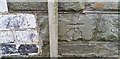
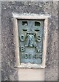
Ordnance Survey Cut Mark
This damaged OS cut mark can be found on No1 Kerry Street. It marks a point 183.371m above mean sea level.
Image: © Adrian Dust
Taken: 28 Apr 2017
0.03 miles
2
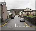
Mace Lane, Ynyswen
Ascending from the A4061 Ynyswen Road. A long derelict former church http://www.geograph.org.uk/photo/5609770 is on the right.
Image: © Jaggery
Taken: 21 Nov 2017
0.04 miles
3
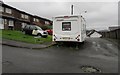
Ynysfeio Close, Ynyswen
Cul-de-sac on the east side of Jones Street.
Image: © Jaggery
Taken: 21 Nov 2017
0.05 miles
4
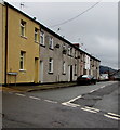
Llewelyn Street, Ynyswen
From Jones Street along Llewelyn Street towards Kenry Street.
Image: © Jaggery
Taken: 21 Nov 2017
0.05 miles
5
Ordnance Survey Flush Bracket (10144)
This OS Flush Bracket can be found on the SW angle of the Chapel. It marks a point 178.528m above mean sea level.
Image: © Adrian Dust
Taken: 28 Apr 2017
0.05 miles
6
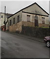
Former Methodist Church, Mace Lane, Ynyswen
In November 2017 mould is well established on the walls of the long-derelict former church erected in 1876.
Image: © Jaggery
Taken: 21 Nov 2017
0.05 miles
7
From Baglan Street to Ynyswen Road, Ynyswen
Viewed across the A4061.
The name sign on the wall on the right shows BAGLAN STREET.
The name sign on the wall on the left shows YNYSWEN ROAD.
Image: © Jaggery
Taken: 21 Nov 2017
0.06 miles
8
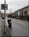
Ynyswen Road speed camera sign, Ynyswen
Alongside the A4061 Ynyswen Road.
Image: © Jaggery
Taken: 21 Nov 2017
0.06 miles
9
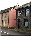
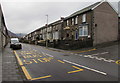
Ynyswen Road houses, Ynyswen
Viewed across the A4061 Ynyswen Road. The A4061 Baglan Street is behind the camera.
Image: © Jaggery
Taken: 21 Nov 2017
0.06 miles
10
Ynyswen Road bus stop opposite Mace Lane, Ynyswen
This stop alongside the A4061 Ynyswen Road is for buses to Blaencwm and Blaenrhondda.
Image: © Jaggery
Taken: 21 Nov 2017
0.06 miles