IMAGES TAKEN NEAR TO
Bute Street, TREORCHY, CF42 6DB
Introduction
This page details the photographs taken nearby to Bute Street, CF42 6DB by members of the Geograph project.
The Geograph project started in 2005 with the aim of publishing, organising and preserving representative images for every square kilometre of Great Britain, Ireland and the Isle of Man.

There are currently over 7.5m images from over14,400 individuals and you can help contribute to the project by visiting https://www.geograph.org.uk
Image Map
Images are licensed for reuse under creativecommons.org/licenses/by-sa/2.0
Notes
- Clicking on the map will re-center to the selected point.
- The higher the marker number, the further away the image location is from the centre of the postcode.
Image Listing (144 Images Found)
Images are licensed for reuse under creativecommons.org/licenses/by-sa/2.0
Image
Details
Distance
1
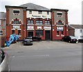
Abergorki Hall, Bute Street, Treorchy
The year 1915 is inscribed on the building, below ABERGORKI HALL. Built as Abergorki Workingmen's Institute, the construction was paid for by a levy paid by the workers of the Abergorky Colliery in Treorchy. There was a cinema in the building from the 1930s until the early 1970s, with c500 seats.
Now (April 2018) used as a community hall. Names on banners include Ystradyfodwg Art Society, Shin-gi-tai aikido, Traditional Korean karate.
Image: © Jaggery
Taken: 9 Apr 2018
0.01 miles
2
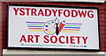
Ystradyfodwg Art Society name sign, Treorchy
On the wall of Abergorki Hall. https://www.geograph.org.uk/photo/5737926
Image: © Jaggery
Taken: 14 Mar 2020
0.01 miles
3
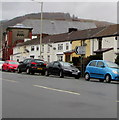
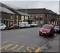
On-street parking, Bute Street, Treorchy
Pointing towards Crichton Street, a sign shows Abergorci Ind(ustrial) Est(ate) and its Welsh equivalent.
Image: © Jaggery
Taken: 14 Mar 2020
0.01 miles
4
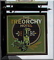
The Treorchy Hotel name sign, Treorchy
Hanging from a wall bracket here. https://www.geograph.org.uk/photo/2790232
Image: © Jaggery
Taken: 9 Apr 2018
0.03 miles
5
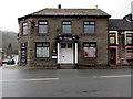
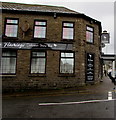
Flamingo entrance, 165 Bute Street, Treorchy
The entrance to the Flamingo Cabaret Show Bar viewed across the A4061 in March 2020.
The Treorchy Hotel was here in 2012. https://www.geograph.org.uk/photo/2790232
Image: © Jaggery
Taken: 14 Mar 2020
0.03 miles
6
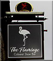
Flamingo name sign, Treorchy
Hanging from a wall bracket on the right here. https://www.geograph.org.uk/photo/6413591
Image: © Jaggery
Taken: 14 Mar 2020
0.03 miles
7
NW along the A4061 Bute Street, Treorchy
Ahead for Ynyswen and Treherbert. The Flamingo https://www.geograph.org.uk/photo/6413573 is in the background.
Image: © Jaggery
Taken: 14 Mar 2020
0.03 miles
8
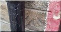
Ordnance Survey Cut Mark
This OS cut mark can be found on the Treorchy Hotel. It marks a point 168.045m above mean sea level.
Image: © Adrian Dust
Taken: 28 Apr 2017
0.03 miles
9
Crichton Street side of the Flamingo Cabaret Show Bar, Treorchy
Flamingo's entrance https://www.geograph.org.uk/photo/6413573 is from Bute Street.
Image: © Jaggery
Taken: 14 Mar 2020
0.04 miles
10
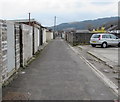
Back lane in Treorchy
From Glynrhondda Street towards Crichton Street.
Image: © Jaggery
Taken: 9 Apr 2018
0.04 miles