IMAGES TAKEN NEAR TO
Dumfries Street, TREORCHY, CF42 5PN
Introduction
This page details the photographs taken nearby to Dumfries Street, CF42 5PN by members of the Geograph project.
The Geograph project started in 2005 with the aim of publishing, organising and preserving representative images for every square kilometre of Great Britain, Ireland and the Isle of Man.

There are currently over 7.5m images from over14,400 individuals and you can help contribute to the project by visiting https://www.geograph.org.uk
Image Map
Images are licensed for reuse under creativecommons.org/licenses/by-sa/2.0
Notes
- Clicking on the map will re-center to the selected point.
- The higher the marker number, the further away the image location is from the centre of the postcode.
Image Listing (206 Images Found)
Images are licensed for reuse under creativecommons.org/licenses/by-sa/2.0
Image
Details
Distance
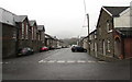
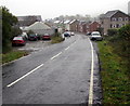
1
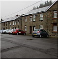
On-street parking, Dumfries Street, Treherbert
This part of Dumfries Street is wide enough for cars to be parked at right angles to the pavement.
Image: © Jaggery
Taken: 26 Oct 2017
0.01 miles
2
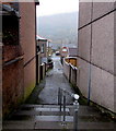
Steps down from Dumfries Street, Treherbert
Descending to a side street to the A4061 Abertonllwyd Street.
Image: © Jaggery
Taken: 26 Oct 2017
0.02 miles
3
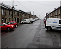
Wide part of Dumfries Street, Treherbert
This part of Dumfries Street is wide enough for cars and vans to be parked at right angles to the pavement.
Image: © Jaggery
Taken: 26 Oct 2017
0.03 miles
4
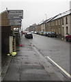
A4061 direction signs, Treherbert
Ahead on the A4061 for Treorchy (Treorci in Welsh). Turn right onto the B4522 for Blaenrhondda.
Image: © Jaggery
Taken: 26 Oct 2017
0.04 miles
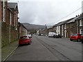
5
Northwestern end of Dumfries Street, Treherbert
Dumfries Street ends 170 metres ahead.
Image: © Jaggery
Taken: 26 Oct 2017
0.04 miles
6
Houses at the western end of Dumfries Street, Treherbert
The roadway ends near trees and bushes.
Image: © Jaggery
Taken: 26 Oct 2017
0.04 miles
7
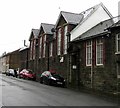
Entrance to Treherbert Community Education Centre
From Dumfries Street. The building is a former school - a faded
inscription in stone on the building shows BOYS SCHOOL REBUILT 1899.
Image: © Jaggery
Taken: 26 Oct 2017
0.04 miles
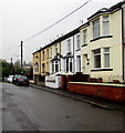
8
Dumfries Street Treherbert
Looking NW past the edge of Treherbert Community Education Centre. http://www.geograph.org.uk/photo/2785215
About 14 metres (c46ft) wide, Dumfries Street is wider than the main road through Treherbert, the A4061.
Image: © Jaggery
Taken: 23 Jan 2012
0.05 miles
9
A4061 into Treherbert
The A4061 Rhigos Road on the camera side becomes the A4061 Abertonllwyd Street beyond the Hill Street junction on the right ahead.
Image: © Jaggery
Taken: 26 Oct 2017
0.05 miles
10
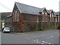
Treherbert Community Education Centre
Located on Dumfries Street in a former school. A faded inscription in stone on the building is
BOYS SCHOOL REBUILT 1899.
Image: © Jaggery
Taken: 23 Jan 2012
0.05 miles