IMAGES TAKEN NEAR TO
Miskin Street, TREORCHY, CF42 5LP
Introduction
This page details the photographs taken nearby to Miskin Street, CF42 5LP by members of the Geograph project.
The Geograph project started in 2005 with the aim of publishing, organising and preserving representative images for every square kilometre of Great Britain, Ireland and the Isle of Man.

There are currently over 7.5m images from over14,400 individuals and you can help contribute to the project by visiting https://www.geograph.org.uk
Image Map (Loading...)


Getting Data...Please wait
Leaflet Map data © OpenStreetMap
Images are licensed for reuse under creativecommons.org/licenses/by-sa/2.0
Notes
- Clicking on the map will re-center to the selected point.
- The higher the marker number, the further away the image location is from the centre of the postcode.
Image Listing (133 Images Found)
Images are licensed for reuse under creativecommons.org/licenses/by-sa/2.0
Image
Details
Distance
1
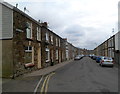
Miskin Street, Tynewydd
Viewed from the Gwendoline Street end looking towards William Street.
Image: © Jaggery
Taken: 23 Jan 2012
0.02 miles
2
Margaret Street, Tynewydd
From Gwendoline Street along Margaret Street towards William Street.
Image: © Jaggery
Taken: 13 Nov 2017
0.03 miles
3
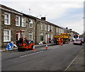
Road resurfacing, Gwendoline Street, Tynewydd
Work in progress on the B4522 Gwendoline Street on November 13th 2017.
Image: © Jaggery
Taken: 13 Nov 2017
0.05 miles
4
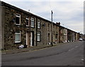
Long row of houses, Gwendoline Street, Tynewydd
Looking to the SE across the B4522 Gwendoline Street.
Image: © Jaggery
Taken: 13 Nov 2017
0.05 miles
5
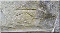
Ordnance Survey Cut Mark
This OS cut mark can be found on No67 Gwendoline Street. It marks a point 188.690m above mean sea level.
Image: © Adrian Dust
Taken: 29 Apr 2017
0.06 miles
6
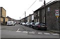
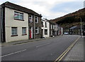
Western end of Miskin Street, Tynewydd
Viewed across Gwendoline Street. Miskin Street leads to William Street.
Image: © Jaggery
Taken: 13 Nov 2017
0.07 miles
7

Park Place, Treherbert
Viewed from the Hill Street end.
Image: © Jaggery
Taken: 23 Jan 2012
0.07 miles
8
Towards a bend in Gwendoline Street, Tynewydd
South along the B4522 Gwendoline Street.
Image: © Jaggery
Taken: 13 Nov 2017
0.07 miles
9
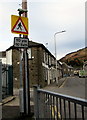
Warning sign - pedestrian crossing 110 yds ahead, Gwendoline Street, Tynewydd
Facing the B4522 Gwendoline Street on the approach to this http://www.geograph.org.uk/photo/5605098 zebra crossing. The text is also in Welsh.
Image: © Jaggery
Taken: 13 Nov 2017
0.08 miles
10
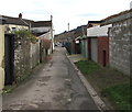
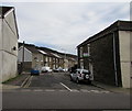
Back lane in Tynewydd
Part of a path from Eileen Place & Eileen Terrace to Gwendoline Street (ahead).
Image: © Jaggery
Taken: 13 Nov 2017
0.08 miles