IMAGES TAKEN NEAR TO
Hill Street, TREORCHY, CF42 5LG
Introduction
This page details the photographs taken nearby to Hill Street, CF42 5LG by members of the Geograph project.
The Geograph project started in 2005 with the aim of publishing, organising and preserving representative images for every square kilometre of Great Britain, Ireland and the Isle of Man.

There are currently over 7.5m images from over14,400 individuals and you can help contribute to the project by visiting https://www.geograph.org.uk
Image Map (Loading...)


Getting Data...Please wait
Leaflet Map data © OpenStreetMap
Images are licensed for reuse under creativecommons.org/licenses/by-sa/2.0
Notes
- Clicking on the map will re-center to the selected point.
- The higher the marker number, the further away the image location is from the centre of the postcode.
Image Listing (181 Images Found)
Images are licensed for reuse under creativecommons.org/licenses/by-sa/2.0
Image
Details
Distance
1
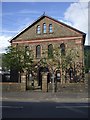
Horeb Chapel, Treherbert. Corner of Hill St and Dunraven St
Image: © John Lord
Taken: 10 Sep 2008
0.02 miles
2
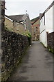
Lane north to Dunraven Street, Treherbert
From a bank of the Rhondda River, the lane leads to Dunraven Street and Plas Horeb. http://www.geograph.org.uk/photo/5599452
Image: © Jaggery
Taken: 13 Nov 2017
0.02 miles
3
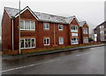
Abertonllwyd Street flats, Treherbert
Viewed across the A4061 Abertonllwyd Street. The corner of Hill Street is on the right.
Image: © Jaggery
Taken: 26 Oct 2017
0.03 miles
4
Abertonllwyd Street, Treherbert
The A4061 Abertonllwyd Street between the A4061 Bute Street and the A4061 Rhigos Road (ahead).
Image: © Jaggery
Taken: 9 Nov 2017
0.03 miles
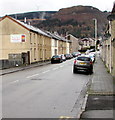
5
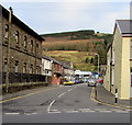
Hill Street, Treherbert
From Dunraven Street along Hill Street towards the A4061. Plas Horeb flats http://www.geograph.org.uk/photo/5599426 are on the left.
Image: © Jaggery
Taken: 13 Nov 2017
0.03 miles
6
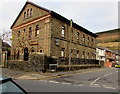
Plas Horeb, Treherbert
Flats on the corner of Dunraven Street and Hill Street.
Built as Horeb Welsh Calvinistic Methodist chapel in 1867, rebuilt in 1905.
Image: © Jaggery
Taken: 13 Nov 2017
0.03 miles
7
A4061 into Treherbert
The A4061 Rhigos Road on the camera side becomes the A4061 Abertonllwyd Street beyond the Hill Street junction on the right ahead.
Image: © Jaggery
Taken: 26 Oct 2017
0.03 miles
8
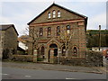
South side of Plas Horeb, Treherbert
The Dunraven Street side of flats http://www.geograph.org.uk/photo/5599426 on the corner of Hill Street.
Built as Horeb Welsh Calvinistic Methodist chapel in 1867, rebuilt in 1905.
Image: © Jaggery
Taken: 13 Nov 2017
0.03 miles
9
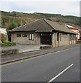
Treherbert Methodist Church
Treherbert Methodist Church in Dunraven Street is part of the Mid Glamorgan Mission Methodist Circuit.
The modern, single-storey brick church occupies part of the site of the demolished English Wesleyan Methodist church, built in 1884.
Image: © Jaggery
Taken: 13 Nov 2017
0.03 miles
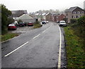
10
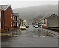
Hill Street, Treherbert
Looking to the SW along Hill Street towards Dunraven Street on a damp and misty day in October 2017.
Image: © Jaggery
Taken: 26 Oct 2017
0.03 miles