IMAGES TAKEN NEAR TO
Treherbert Industrial Estate, TREORCHY, CF42 5HZ
Introduction
This page details the photographs taken nearby to Treherbert Industrial Estate, CF42 5HZ by members of the Geograph project.
The Geograph project started in 2005 with the aim of publishing, organising and preserving representative images for every square kilometre of Great Britain, Ireland and the Isle of Man.

There are currently over 7.5m images from over14,400 individuals and you can help contribute to the project by visiting https://www.geograph.org.uk
Image Map (Loading...)


Getting Data...Please wait
Leaflet Map data © OpenStreetMap
Images are licensed for reuse under creativecommons.org/licenses/by-sa/2.0
Notes
- Clicking on the map will re-center to the selected point.
- The higher the marker number, the further away the image location is from the centre of the postcode.
Image Listing (223 Images Found)
Images are licensed for reuse under creativecommons.org/licenses/by-sa/2.0
Image
Details
Distance
1
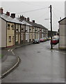
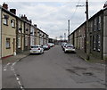
Cwmsaerbren Street, Treherbert
Part of a long dead-end street viewed from Station Street.
In October 2017 many satellite dishes are in view at first floor level.
Image: © Jaggery
Taken: 26 Oct 2017
0.04 miles
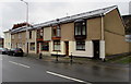
2
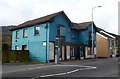
131 Bute Street, Treherbert
Planning approval was given in June 2008 for the construction of an 8 bedroom residential care home here, but at the January 2012 date of this view, the property was empty and for sale.
Image: © Jaggery
Taken: 23 Jan 2012
0.04 miles
3
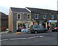
Treherbert Post Office
The post office is at 133 Bute Street Treherbert.
Its neighbour on the left at number 132 is Pawz & Clawz, pet food and supplies. The premises were formerly occupied by Wagtails Pet & Garden Supplies.
Its neighbour on the right at number 134 is a branch of Coventry Building Society, previously a branch of Stroud & Swindon Building Society, which merged with the Coventry in 2010.
Image: © Jaggery
Taken: 23 Jan 2012
0.04 miles
4
Brynfedwen Close, Treherbert
Cul-de-sac between Bute Street and the Rhondda River.
Image: © Jaggery
Taken: 9 Nov 2017
0.05 miles
5
Satellite dishes, Cwmsaerbren Street, Treherbert
In March 2020 many satellite dishes are on the left side of the dead-end street.
Image: © Jaggery
Taken: 6 Mar 2020
0.05 miles
6
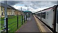
Station Terrace houses, Treherbert
Viewed from Treherbert station platform 1 in March 2024.
Image: © Jaggery
Taken: 1 Mar 2024
0.06 miles
7
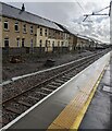
Treherbert station looking south
A minimalist facility at the end of the line from Cardiff. The 17.16 to Cardiff Central will soon leave.
Image: © Peter Whatley
Taken: 30 May 2022
0.06 miles
8
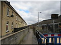
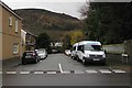
Path past Station Terrace houses, Treherbert
Treherbert railway station is on the right.
Image: © Jaggery
Taken: 6 Mar 2020
0.07 miles
9
Row of houses, Bute Street, Treherbert
Viewed across the A4061 Bute Street.
Image: © Jaggery
Taken: 9 Nov 2017
0.07 miles
10

Ordnance Survey Cut Mark
This OS cut mark can be found on the wall of Brynfedwen House, Bute Street. It marks a point 185.847m above mean sea level.
Image: © Adrian Dust
Taken: 9 Nov 2020
0.08 miles