IMAGES TAKEN NEAR TO
Brynheulog, TREORCHY, CF42 5HB
Introduction
This page details the photographs taken nearby to Brynheulog, CF42 5HB by members of the Geograph project.
The Geograph project started in 2005 with the aim of publishing, organising and preserving representative images for every square kilometre of Great Britain, Ireland and the Isle of Man.

There are currently over 7.5m images from over14,400 individuals and you can help contribute to the project by visiting https://www.geograph.org.uk
Image Map
Images are licensed for reuse under creativecommons.org/licenses/by-sa/2.0
Notes
- Clicking on the map will re-center to the selected point.
- The higher the marker number, the further away the image location is from the centre of the postcode.
Image Listing (88 Images Found)
Images are licensed for reuse under creativecommons.org/licenses/by-sa/2.0
Image
Details
Distance
1
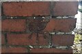
Ordnance Survey Cut Mark
This damaged OS cut mark can be found on the garage SE side of Corbett Street. It marks a point 200.379m above mean sea level.
Image: © Adrian Dust
Taken: 9 Nov 2020
0.06 miles
2
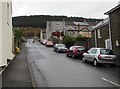
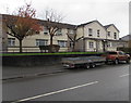
On-street parking, Corbett Street, Treherbert
Corbett Street ascends from Bute Street towards Dumfries Street and Mount Libanus Street.
Image: © Jaggery
Taken: 9 Nov 2017
0.08 miles
3
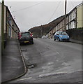
Mount Libanus Street, Treherbert
The SE end of Mount Libanus Street viewed from the corner of Mary Street. Libanus is Welsh for Lebanon.
Image: © Jaggery
Taken: 9 Nov 2017
0.09 miles
4
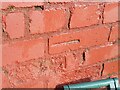
Ordnance Survey Cut Mark
This OS cut mark can be found on the wall of No21 Bryn Heulog. It marks a point 211.671m above mean sea level.
Image: © Adrian Dust
Taken: 9 Nov 2020
0.09 miles
5
Tŷ Heddlu flats, Bute Street, Treherbert
Tŷ Heddlu is Welsh for Police House, which suggests that the flats occupy
the site of Treherbert Police Station which was demolished a decade or more ago.
Image: © Jaggery
Taken: 9 Nov 2017
0.10 miles
6
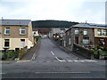
Corbett Street, Treherbert
Corbett Street climbs away from Bute Street (A4061).
Image: © Jaggery
Taken: 23 Jan 2012
0.11 miles
7
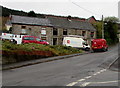
Royal Mail van, John Street, Treherbert
The red van is parked in John Street while its driver delivers letters and small parcels to nearby houses.
Image: © Jaggery
Taken: 9 Nov 2017
0.11 miles
8
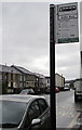
Welsh side of a bus stop sign, Bute Street, Treherbert
This side shows the Welsh Garej Tapper. The letter J/j is rarely used in Welsh,
mainly in words derived from other languages, such as here.
The opposite side of the sign shows Tapper's Garage. https://www.geograph.org.uk/photo/5628507
Image: © Jaggery
Taken: 9 Nov 2017
0.12 miles
9
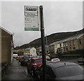
English side of a bus stop sign, Bute Street, Treherbert
This side of the sign located here https://www.geograph.org.uk/photo/5628503 shows Tapper's Garage. The other side shows the Welsh Garej Tapper. https://www.geograph.org.uk/photo/5628509
Image: © Jaggery
Taken: 9 Nov 2017
0.12 miles
10
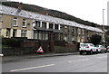
Slate roofs, Bute Street, Treherbert
Viewed across the A4061 Bute Street from the corner of Brynfedwen Close.
Image: © Jaggery
Taken: 9 Nov 2017
0.12 miles