IMAGES TAKEN NEAR TO
Gwendoline Street, TREORCHY, CF42 5BW
Introduction
This page details the photographs taken nearby to Gwendoline Street, CF42 5BW by members of the Geograph project.
The Geograph project started in 2005 with the aim of publishing, organising and preserving representative images for every square kilometre of Great Britain, Ireland and the Isle of Man.

There are currently over 7.5m images from over14,400 individuals and you can help contribute to the project by visiting https://www.geograph.org.uk
Image Map
Images are licensed for reuse under creativecommons.org/licenses/by-sa/2.0
Notes
- Clicking on the map will re-center to the selected point.
- The higher the marker number, the further away the image location is from the centre of the postcode.
Image Listing (115 Images Found)
Images are licensed for reuse under creativecommons.org/licenses/by-sa/2.0
Image
Details
Distance
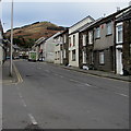
1
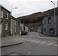
Gwendoline Street, Tynewydd
The unclassified Gwendoline Street on the camera side becomes the B4522 Gwendoline Street ahead.
Image: © Jaggery
Taken: 13 Nov 2017
0.00 miles
2
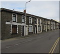
Row of stone houses, Gwendoline Street, Tynewydd
On the west side of the B4522 Gwendoline Street.
Image: © Jaggery
Taken: 13 Nov 2017
0.01 miles
3
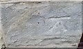
Ordnance Survey Cut Mark
This OS cut mark can be found on No7 Gwendoline Street. It marks a point 194.572m above mean sea level.
Image: © Adrian Dust
Taken: 29 Apr 2017
0.01 miles
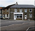
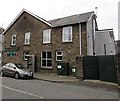
4
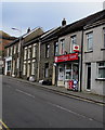
The Village Store and Post Office, Tynewydd
At 9 Gwendoline Street near the corner of Miskin Street.
Image: © Jaggery
Taken: 13 Nov 2017
0.01 miles
5
Up Gwendoline Street towards the Village Store and Post Office, Tynewydd
The B4522 Gwendoline Street ascends towards the Village Store and Post Office http://www.geograph.org.uk/photo/5600135 to the right of the van.
Image: © Jaggery
Taken: 13 Nov 2017
0.01 miles
6
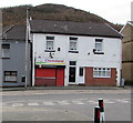
Chickoland takeaway, Gwendoline Street, Tynewydd
Viewed in November 2017. An August 2012 Google Earth Street View shows Wyndham Grill takeaway here.
Image: © Jaggery
Taken: 13 Nov 2017
0.02 miles
7
Johnny's Petals in Tynewydd
Florist at 5 Gwendoline Street.
Image: © Jaggery
Taken: 13 Nov 2017
0.02 miles
8
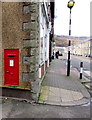
King George VI postbox in a shop side wall, Tynewydd
Located here https://www.geograph.org.uk/photo/5625622 in the side wall of Rhondda Riding Disabled Group charity shop.
The shop used to be a post office.
King George VI reigned from December 11th 1936 to February 6th 1952.
Image: © Jaggery
Taken: 13 Nov 2017
0.02 miles
9
BT phonebox and telecoms cabinet, Gwendoline Street, Tynewydd
On the Gwendoline Street side of the Wyndham pub https://www.geograph.org.uk/photo/5605166 on the corner of Wyndham Street.
Image: © Jaggery
Taken: 13 Nov 2017
0.02 miles
10
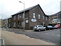
The Wyndham, Tynewydd
Pub on the corner of Wyndham Street and Gwendoline Street. There were To Let signs on the building (January 2012) and all the windows had protective metal coverings.
Image: © Jaggery
Taken: 23 Jan 2012
0.02 miles