IMAGES TAKEN NEAR TO
Swn Yr Afon, PENTRE, CF41 7UN
Introduction
This page details the photographs taken nearby to Swn Yr Afon, CF41 7UN by members of the Geograph project.
The Geograph project started in 2005 with the aim of publishing, organising and preserving representative images for every square kilometre of Great Britain, Ireland and the Isle of Man.

There are currently over 7.5m images from over14,400 individuals and you can help contribute to the project by visiting https://www.geograph.org.uk
Image Map
Images are licensed for reuse under creativecommons.org/licenses/by-sa/2.0
Notes
- Clicking on the map will re-center to the selected point.
- The higher the marker number, the further away the image location is from the centre of the postcode.
Image Listing (53 Images Found)
Images are licensed for reuse under creativecommons.org/licenses/by-sa/2.0
Image
Details
Distance
1
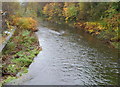
Rhondda Fawr downstream from Tyisaf Road bridge, Gelli
The river flows eastwards away from this http://www.geograph.org.uk/photo/3066271 bridge.
Image: © Jaggery
Taken: 3 Nov 2011
0.02 miles
2
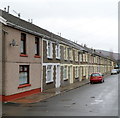
Dorothy Street houses, Gelli
The north side of Dorothy Street viewed from the corner of Mount Zion Pentecostal Church. http://www.geograph.org.uk/photo/3066235
At the far end of the street are riverside railings and a footbridge over the Rhondda Fawr river.
Image: © Jaggery
Taken: 3 Nov 2011
0.04 miles
3
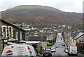
A view from Hillside Terrace, Gelli
Looking along Hillside Terrace and Tyisaf Road. The high ground in the distance is the slope of Mynydd yr Eglwys, part of the range separating the valley of the Rhondda Fawr river on this side from the valley of the Rhondda Fach river on the far side of the range.
Image: © Jaggery
Taken: 3 Nov 2011
0.05 miles
4
Gelli Post Office
Located in Tyisaf Road. A few metres from the postbox on the left, there is a disused George V postbox in the wall. The former postbox's aperture is sealed off.
Image: © Jaggery
Taken: 3 Nov 2011
0.06 miles
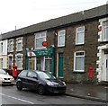
5
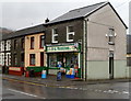
Monkton's Stores, Gelli
D.G.Monkton Ltd off licence and general stores, located on the corner of Tyisaf Road and Ystrad Terrace.
Image: © Jaggery
Taken: 3 Nov 2011
0.06 miles
6
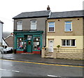
Joan's Wool Shop, Gelli
The dark green shop on the corner of Tyisaf Road and Dorothy Street has no nameboard on display. Notices in the window and on the glass above the doorway show that this is Joan's Wool Shop.
Image: © Jaggery
Taken: 3 Nov 2011
0.06 miles
7
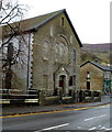
Mount Zion Pentecostal Church, Gelli
Located on the corner of Tyisaf Road and Dorothy Street.
Formerly Duffryn Welsh Calvinistic Methodist Chapel, built in the 1890s.
Image: © Jaggery
Taken: 3 Nov 2011
0.06 miles
8
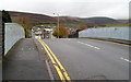
Tyisaf Road railway bridge, Gelli
The bridge carries the road over the Merthyr Line, here single track. A plate fixed to the bridge records that it was made by Patent Shaft & Axletree Co Ltd of Wednesbury in 1932.
Image: © Jaggery
Taken: 3 Nov 2011
0.06 miles
9
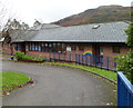
Gelli Primary School
Viewed from Ystrad Road (A4058).
Image: © Jaggery
Taken: 3 Nov 2011
0.06 miles
10
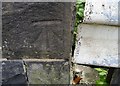
Ordnance Survey Cut Mark
This OS cut mark can be found on east wall of the railway bridge. It marks a point 153.241m above mean sea level.
Image: © Adrian Dust
Taken: 7 May 2017
0.06 miles