IMAGES TAKEN NEAR TO
Gelli Terrace, PENTRE, CF41 7UL
Introduction
This page details the photographs taken nearby to Gelli Terrace, CF41 7UL by members of the Geograph project.
The Geograph project started in 2005 with the aim of publishing, organising and preserving representative images for every square kilometre of Great Britain, Ireland and the Isle of Man.

There are currently over 7.5m images from over14,400 individuals and you can help contribute to the project by visiting https://www.geograph.org.uk
Image Map
Images are licensed for reuse under creativecommons.org/licenses/by-sa/2.0
Notes
- Clicking on the map will re-center to the selected point.
- The higher the marker number, the further away the image location is from the centre of the postcode.
Image Listing (48 Images Found)
Images are licensed for reuse under creativecommons.org/licenses/by-sa/2.0
Image
Details
Distance
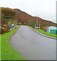
1
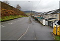
B4223 passes Gelli Terrace, Gelli
Heading towards the centre of Gelli, the B4223 passes an outlying area of housing.
Image: © Jaggery
Taken: 3 Nov 2011
0.03 miles
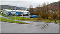
2
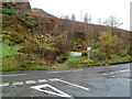
High ground behind the B4223 junction near Gelli Industrial Estate
Turn left for Tonypandy and Llwynypia or right for Gelli.
Access to Gelli Industrial estate is along the road from where this view was taken.
Image: © Jaggery
Taken: 3 Nov 2011
0.03 miles
3
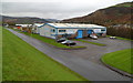
Eastern side of Gelli Industrial Estate
Nearest the camera are Eskimo Joe's, a snow and ice-themed playcentre located in unit 46, (the former Monster Madness Playcentre site) and Futureglaze windows showroom.
Image: © Jaggery
Taken: 3 Nov 2011
0.07 miles
4
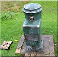
Unusual roadside hydrant, Gelli Industrial Estate
Located on the side of the access road http://www.geograph.org.uk/photo/3064780 from the B4223 to Gelli Industrial Estate.
The hydrant was made by Bayard, a waterworks equipment manufacturer founded in 1881 in the French city of Lyons, where the company is still based today.
Image: © Jaggery
Taken: 3 Nov 2011
0.07 miles
5
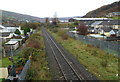
Rhondda Line railway, Gelli
Viewed from this http://www.geograph.org.uk/photo/3064906 footbridge.
The next station on the Rhondda Line is this direction is Ystrad Rhondda. http://www.geograph.org.uk/photo/2793454
Image: © Jaggery
Taken: 3 Nov 2011
0.09 miles
6
Access road, Gelli Industrial Estate
The road from the B4223 descends into Gelli Industrial Estate.
On the pavement on the right is a French-made hydrant. http://www.geograph.org.uk/photo/3064773
Image: © Jaggery
Taken: 3 Nov 2011
0.10 miles
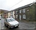
7
Ynysgau Street, Gelli
A cul-de-sac on the south bank of the Rhondda Fawr river, viewed from the Gelli Crossing http://www.geograph.org.uk/photo/3064896 end.
Image: © Jaggery
Taken: 3 Nov 2011
0.11 miles
8
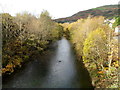
Rhondda Fawr flows towards Ystrad Rhondda station access footbridge
Viewed from this footbridge. http://www.geograph.org.uk/photo/2793362
Image: © Jaggery
Taken: 28 Oct 2011
0.11 miles
9
Leaving Gelli Industrial Estate
The road climbs away from Gelli Industrial Estate towards the B4223.
Image: © Jaggery
Taken: 3 Nov 2011
0.11 miles
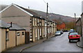
10
Shady Road, Gelli
Viewed from the railway footbridge http://www.geograph.org.uk/photo/3064906 end of the street. According to one source, this is the only Shady Road in the UK, though there are about a dozen streets named Shady Lane.
Image: © Jaggery
Taken: 3 Nov 2011
0.14 miles