IMAGES TAKEN NEAR TO
New King Street, PENTRE, CF41 7TF
Introduction
This page details the photographs taken nearby to New King Street, CF41 7TF by members of the Geograph project.
The Geograph project started in 2005 with the aim of publishing, organising and preserving representative images for every square kilometre of Great Britain, Ireland and the Isle of Man.

There are currently over 7.5m images from over14,400 individuals and you can help contribute to the project by visiting https://www.geograph.org.uk
Image Map
Images are licensed for reuse under creativecommons.org/licenses/by-sa/2.0
Notes
- Clicking on the map will re-center to the selected point.
- The higher the marker number, the further away the image location is from the centre of the postcode.
Image Listing (41 Images Found)
Images are licensed for reuse under creativecommons.org/licenses/by-sa/2.0
Image
Details
Distance
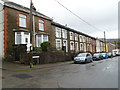
1
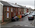
King Street houses, Gelli
Houses on the north side of the street, viewed from the corner of Smith Street looking towards Ravenhill Street.
Image: © Jaggery
Taken: 3 Nov 2011
0.03 miles
2
Bronllwyn Road houses, Gelli
Houses on the north side of Bronllwyn Road viewed from the corner of Smith Street.
Image: © Jaggery
Taken: 3 Nov 2011
0.03 miles
3
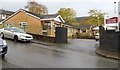
Bronllwyn Integrated Resource Centre, Gelli
Viewed across Smith Street. The Rhondda Cynon Taf premises include a residential care unit and day services.
Image: © Jaggery
Taken: 3 Nov 2011
0.03 miles
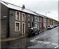
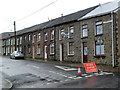
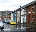
5
Llanfair Hill houses, Gelli
Houses on the south side of the street viewed from the corner of Smith Street.
Image: © Jaggery
Taken: 3 Nov 2011
0.06 miles
6
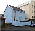
Bryn Seion House, Gelli
Located in Smith Street, next door to Bryn Seion Court. http://www.geograph.org.uk/photo/3066486
Bryn Seion Court occupies the site of a demolished chapel, so perhaps Bryn Seion House is a modernised version (or a rebuild) of the former chapel minister's house.
Image: © Jaggery
Taken: 3 Nov 2011
0.06 miles
7
Avondale Road houses, Gelli
Houses on the south side of the road viewed from the edge of Bryn Seion Court. http://www.geograph.org.uk/photo/3066486
Image: © Jaggery
Taken: 3 Nov 2011
0.06 miles
8
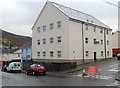
Bryn Seion Court, Gelli
A block of 12 flats on the corner of Avondale Road and Smith Street.
The building occupies the site of the demolished Bryn Seion Welsh Independent chapel.
Image: © Jaggery
Taken: 3 Nov 2011
0.06 miles
9
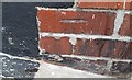
Ordnance Survey Cut Mark
This OS cut mark can be found on No11 Llanfair Hill. It marks a point 169.938m above mean sea level.
Image: © Adrian Dust
Taken: 7 May 2017
0.06 miles
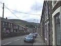
10
One-way system, Bronllwyn Road,Gelli
There is a one-way system operating along this part of Bronllwyn Road, west of Smith Street.
Image: © Jaggery
Taken: 3 Nov 2011
0.07 miles