IMAGES TAKEN NEAR TO
Ffordd Seren, PENTRE, CF41 7TB
Introduction
This page details the photographs taken nearby to Ffordd Seren, CF41 7TB by members of the Geograph project.
The Geograph project started in 2005 with the aim of publishing, organising and preserving representative images for every square kilometre of Great Britain, Ireland and the Isle of Man.

There are currently over 7.5m images from over14,400 individuals and you can help contribute to the project by visiting https://www.geograph.org.uk
Image Map
Images are licensed for reuse under creativecommons.org/licenses/by-sa/2.0
Notes
- Clicking on the map will re-center to the selected point.
- The higher the marker number, the further away the image location is from the centre of the postcode.
Image Listing (80 Images Found)
Images are licensed for reuse under creativecommons.org/licenses/by-sa/2.0
Image
Details
Distance
1
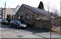
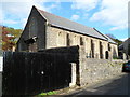
Providence Church, Ystrad
At the southern end of Trafalgar Terrace. There is a cross on the building but no name sign.
Image: © Jaggery
Taken: 30 Mar 2015
0.03 miles
2
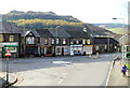
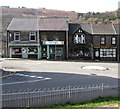
Gelligaled Road shops, Ystrad
Shops at the eastern end of Gelligaled Road (the local name for the A4058) viewed from Penrhys Road.
Image: © Jaggery
Taken: 28 Oct 2011
0.04 miles
3

Ystrad Clinic
National Health Service clinic on the east side of Trafalgar Terrace, Ystrad.
Image: © Jaggery
Taken: 30 Mar 2015
0.05 miles
4
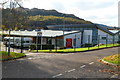
Ysgol Hen Felin, Ystrad
The school, located in Gelligaled Park, is a day community school for 140 pupils aged from 3 to 19 with statements of Special Educational Needs. These include severe learning difficulties, profound and multiple learning difficulties, hearing impaired, and emotional and behavioural difficulties.
Image: © Jaggery
Taken: 28 Oct 2011
0.05 miles
5
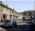
Trafalgar Terrace, Ystrad
Looking towards Gelligaled Road from the southern end of Trafalgar Terrace.
Providence Church http://www.geograph.org.uk/photo/4406422 is out of shot on the right.
Image: © Jaggery
Taken: 30 Mar 2015
0.06 miles
6
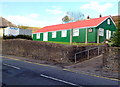
Ystrad OAP Association hall
The distinctive red and green corrugated metal building is on the north side of Tyntyla Road (A4058) near the junction with the B4512 (Penrhys Road).
Image: © Jaggery
Taken: 28 Oct 2011
0.06 miles
7
St Stephen's church, Ystrad
Located on the north side of the junction of Penrhys Road and Tyntyla Road.
The Church in Wales church, which opened in May 1896, is in the parish of Ystrad Rhondda with Ynyscynon, diocese of Llandaff.
Image: © Jaggery
Taken: 28 Oct 2011
0.06 miles
8
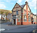
The Star, Ystrad
Pub on the corner of Tyntyla Road and Penrhys Road.
The name engraved in stone above the corner entrance is STAR GELLIDAWEL HOTEL.
The year 1913 and a six-pointed star are at the top of the building.
Image: © Jaggery
Taken: 28 Oct 2011
0.06 miles
9
Ruby's Chinese takeaway, Ystrad
The takeaway at 50 Gelligaled Road is next door to a shop which appears to be shared by DG Window Systems and Thomas Lettings.
Image: © Jaggery
Taken: 30 Mar 2015
0.07 miles
10
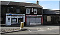
Four Gelligaled Road premises, Ystrad
Sheppards Pharmacy on the left is on the corner of Mill Street.
Also in view are the Rhondda office of political party Plaid Cymru,
U Design embroidery and print shop and Hair Kraft unisex hair salon.
Image: © Jaggery
Taken: 30 Mar 2015
0.07 miles