IMAGES TAKEN NEAR TO
Buckland Drive, PENTRE, CF41 7SR
Introduction
This page details the photographs taken nearby to Buckland Drive, CF41 7SR by members of the Geograph project.
The Geograph project started in 2005 with the aim of publishing, organising and preserving representative images for every square kilometre of Great Britain, Ireland and the Isle of Man.

There are currently over 7.5m images from over14,400 individuals and you can help contribute to the project by visiting https://www.geograph.org.uk
Image Map
Images are licensed for reuse under creativecommons.org/licenses/by-sa/2.0
Notes
- Clicking on the map will re-center to the selected point.
- The higher the marker number, the further away the image location is from the centre of the postcode.
Image Listing (32 Images Found)
Images are licensed for reuse under creativecommons.org/licenses/by-sa/2.0
Image
Details
Distance
1
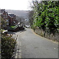
Buckland Drive, Ystrad
Buckland Drive descends from Penrhys Road towards Eisteddfa Road, Llwynypia.
This is not a through route for motor vehicles because there are concrete posts
across the roadway at Eisteddfa Road. The posts are no barrier for walkers and cyclists.
Image: © Jaggery
Taken: 30 Mar 2015
0.03 miles
2
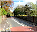
Penrhys Road climbs eastwards away from Ystrad
Viewed from alongside Old Penrhys Road, just out of shot on the right. The junction on the left is one of two roads from Penrhys Road to Danygraig and Danycoed.
Image: © Jaggery
Taken: 28 Oct 2011
0.06 miles
3
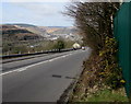
Down Penrhys Road towards the centre of Ystrad
From the edge of a Welsh Water compound http://www.geograph.org.uk/photo/4409417 at a height of 235 metres (770 ft) above sea level (ASL).
This is a small part of a long steep descent from the lowest part of Penrhys at 285 metres (935 ft) ASL
to Ystrad at 170 metres (560 ft) ASL.
A sign at the top of the descent shows a 12% gradient (between 1 in 8 and 1 in 9).
Another sign tells motor vehicle drivers to stay in low gear for 1 mile.
Image: © Jaggery
Taken: 30 Mar 2015
0.07 miles
4
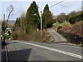
Side road from Penrhys Road, Ystrad
A flattish side road diverges from the steep B4512 Penrhys Road.
Image: © Jaggery
Taken: 30 Mar 2015
0.07 miles
5
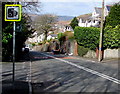
Speed camera sign, Penrhys Road, Ystrad
On the corner of Buckland Drive, the sign is alongside the long steep descent from Penrhys to Ystrad.
Image: © Jaggery
Taken: 30 Mar 2015
0.07 miles
6
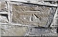
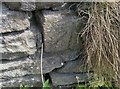
Ordnance Survey Cut Mark
This OS cut mark can be found on the wall of No67 Penrhys Road. It marks a point 196.752m above mean sea level.
Image: © Adrian Dust
Taken: 7 May 2017
0.08 miles
7
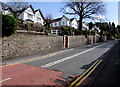
Penrhys Road houses east of Old Penrhys Road, Ystrad
On the north side of the long, steep ascent from Ystrad to Penrhys.
Image: © Jaggery
Taken: 30 Mar 2015
0.09 miles
8
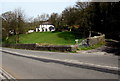
White house on a hillside near Penrhys
Set back 50 metres from the north side of the B4512 Penrhys Road.
Image: © Jaggery
Taken: 30 Mar 2015
0.09 miles
9
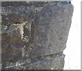
Ordnance Survey Cut Mark
This OS cut mark can be found on the wall north side of the road. It marks a point 225.640m above mean sea level.
Image: © Adrian Dust
Taken: 7 May 2017
0.10 miles
10
Ordnance Survey Cut Mark
This OS cut mark can be found on the wall at the bottom of the steps. It marks a point 154.744m above mean sea level.
Image: © Adrian Dust
Taken: 7 May 2017
0.10 miles