IMAGES TAKEN NEAR TO
Tyntyla Road, PENTRE, CF41 7SF
Introduction
This page details the photographs taken nearby to Tyntyla Road, CF41 7SF by members of the Geograph project.
The Geograph project started in 2005 with the aim of publishing, organising and preserving representative images for every square kilometre of Great Britain, Ireland and the Isle of Man.

There are currently over 7.5m images from over14,400 individuals and you can help contribute to the project by visiting https://www.geograph.org.uk
Image Map
Images are licensed for reuse under creativecommons.org/licenses/by-sa/2.0
Notes
- Clicking on the map will re-center to the selected point.
- The higher the marker number, the further away the image location is from the centre of the postcode.
Image Listing (58 Images Found)
Images are licensed for reuse under creativecommons.org/licenses/by-sa/2.0
Image
Details
Distance
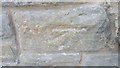
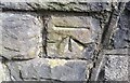
1
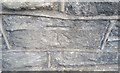
Ordnance Survey Cut Mark
This OS cut mark can be found on the wall of No24 Penrhys Road. It marks a point 163.347m above mean sea level.
Image: © Adrian Dust
Taken: 7 May 2017
0.03 miles
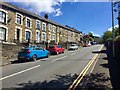
2
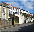
Penrhys Road houses, Ystrad
Houses on the north side of Penrhys Road, located west of the turning for Danycoed and Danygraig.
Image: © Jaggery
Taken: 28 Oct 2011
0.03 miles
3
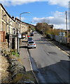
Penrhys Road, Ystrad
The B4512 climbs away from the A4058. The village of Penrhys is about a mile away,
located at about 1,100 feet above mean sea level.
Image: © Jaggery
Taken: 28 Oct 2011
0.03 miles
4
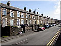
Long row of houses, Penrhys Road, Ystrad
Extending for nearly 100 metres along the north side of Penrhys Road.
Image: © Jaggery
Taken: 30 Mar 2015
0.03 miles
5
Penrhys Road
Terraced housing on Penrhys Road.
Image: © Alan Hughes
Taken: 4 May 2019
0.04 miles
6
Ordnance Survey Cut Mark
This OS cut mark can be found on No238 Tyntyla Road. It marks a point 153.711m above mean sea level.
Image: © Adrian Dust
Taken: 7 May 2017
0.05 miles
7
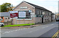
Ystrad Rhondda Labour Club
Located at 236 Tyntyla Road, Ystrad, on the corner of the access road for Rhondda Sports Centre.
Image: © Jaggery
Taken: 28 Oct 2011
0.06 miles
8
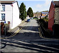
One-way road to Danygraig and Danycoed, Ystrad
The road towards the streets named Danygraig and Danycoed climbs away from Penrhys Road.
The exit road to Penrhys Road is 150 metres to the right (east).
Image: © Jaggery
Taken: 30 Mar 2015
0.07 miles
9
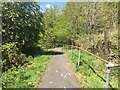
Footpath through woodland
Steep path leading downhill between trees to Penrhys Road.
Image: © Alan Hughes
Taken: 4 May 2019
0.08 miles
10
Ordnance Survey Cut Mark
This OS cut mark can be found on the wall of No40 Penrhys Road. It marks a point 175.790m above mean sea level
Image: © Adrian Dust
Taken: 7 May 2017
0.08 miles