IMAGES TAKEN NEAR TO
Vicarage Close, PENTRE, CF41 7RR
Introduction
This page details the photographs taken nearby to Vicarage Close, CF41 7RR by members of the Geograph project.
The Geograph project started in 2005 with the aim of publishing, organising and preserving representative images for every square kilometre of Great Britain, Ireland and the Isle of Man.

There are currently over 7.5m images from over14,400 individuals and you can help contribute to the project by visiting https://www.geograph.org.uk
Image Map
Images are licensed for reuse under creativecommons.org/licenses/by-sa/2.0
Notes
- Clicking on the map will re-center to the selected point.
- The higher the marker number, the further away the image location is from the centre of the postcode.
Image Listing (67 Images Found)
Images are licensed for reuse under creativecommons.org/licenses/by-sa/2.0
Image
Details
Distance
1
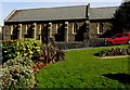
Church of St Stephen, Ystrad Rhondda
The church is part of the Church in Wales Parish of Trealaw with Ystrad Rhondda
with Ynyscynon in the Diocese of Llandaff. The church was built in 1895-1896.
Image: © Jaggery
Taken: 30 Mar 2015
0.03 miles
2
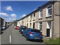
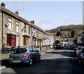
Chapel Street
Typical valleys terraced housing in Ystrad.
Image: © Alan Hughes
Taken: 4 May 2019
0.05 miles
3
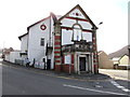
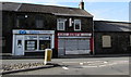
Nisa Local, Ystrad
The convenience store is at 1 Tyntyla Road, on the corner of Penrhys Road.
Evidence of the building's earlier usage remains in view - STAR GELLIDAWEL HOTEL and the year 1913.
Image: © Jaggery
Taken: 30 Mar 2015
0.05 miles
4
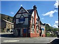
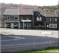
The Star Hotel, Gellidawel
Although the building dates only from 1913 it stands on the site of a much older hostelry which is claimed to be the oldest in the valleys. It stands on the junction of Tyntyla Road (right) and Penrhys Road which is the only road joining the Rhondda Fawr and Rhondda Fach valleys.
For further fascinating information:
https://www.coflein.gov.uk/en/site/404937/details/star-hotel-tynyla-raod-ystrad
Image: © Alan Hughes
Taken: 4 May 2019
0.06 miles
5
Ruby's Chinese takeaway, Ystrad
The takeaway at 50 Gelligaled Road is next door to a shop which appears to be shared by DG Window Systems and Thomas Lettings.
Image: © Jaggery
Taken: 30 Mar 2015
0.06 miles
6
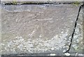
Ordnance Survey Cut Mark
This OS cut mark can be found on the wall south side of the road. It marks a point 153.375m above mean sea level.
Image: © Adrian Dust
Taken: 7 May 2017
0.06 miles
7
Four Gelligaled Road premises, Ystrad
Sheppards Pharmacy on the left is on the corner of Mill Street.
Also in view are the Rhondda office of political party Plaid Cymru,
U Design embroidery and print shop and Hair Kraft unisex hair salon.
Image: © Jaggery
Taken: 30 Mar 2015
0.06 miles
8
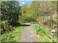
Footpath through woodland
Steep path leading downhill between trees to Penrhys Road.
Image: © Alan Hughes
Taken: 4 May 2019
0.06 miles
9
Trafalgar Terrace, Ystrad
Looking towards Gelligaled Road from the southern end of Trafalgar Terrace.
Providence Church http://www.geograph.org.uk/photo/4406422 is out of shot on the right.
Image: © Jaggery
Taken: 30 Mar 2015
0.08 miles
10
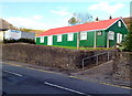
Ystrad OAP Association hall
The distinctive red and green corrugated metal building is on the north side of Tyntyla Road (A4058) near the junction with the B4512 (Penrhys Road).
Image: © Jaggery
Taken: 28 Oct 2011
0.08 miles