IMAGES TAKEN NEAR TO
Nantgwyddon Close, PENTRE, CF41 7RD
Introduction
This page details the photographs taken nearby to Nantgwyddon Close, CF41 7RD by members of the Geograph project.
The Geograph project started in 2005 with the aim of publishing, organising and preserving representative images for every square kilometre of Great Britain, Ireland and the Isle of Man.

There are currently over 7.5m images from over14,400 individuals and you can help contribute to the project by visiting https://www.geograph.org.uk
Image Map
Images are licensed for reuse under creativecommons.org/licenses/by-sa/2.0
Notes
- Clicking on the map will re-center to the selected point.
- The higher the marker number, the further away the image location is from the centre of the postcode.
Image Listing (68 Images Found)
Images are licensed for reuse under creativecommons.org/licenses/by-sa/2.0
Image
Details
Distance
1
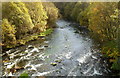
Rhondda Fawr flows away from Ystrad Rhondda railway station
Viewed from the ramp http://www.geograph.org.uk/photo/2793514 descending to the station from a long footbridge. After flowing under http://www.geograph.org.uk/photo/2793400 part of the station, The Rhondda Fawr heads southwards away from the station.
Image: © Jaggery
Taken: 28 Oct 2011
0.03 miles
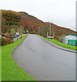
2
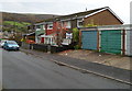
Nantgwyddon Close, Gelli
Located on the south side of Ystrad Rhondda railway station.
Image: © Jaggery
Taken: 3 Nov 2011
0.05 miles
3
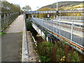
Long footbridge to Ystrad Rhondda railway station
Spanning the Rhondda Fawr river and the twin-track Rhondda Line, the footbridge connects Brook Street with the station.
Image: © Jaggery
Taken: 28 Oct 2011
0.05 miles
4
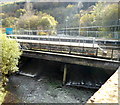
Rhondda Fawr flows under Ystrad Rhondda railway station
Part of Ystrad Rhondda railway station is on a bridge over the Rhondda Fawr river.
Image: © Jaggery
Taken: 28 Oct 2011
0.05 miles
5
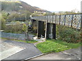
Entrance ramp to Ystrad Rhondda railway station
The ramp descends at right angles from a long footbridge http://www.geograph.org.uk/photo/2793362 from Brook Street, across the Rhondda Fawr river, to Nant Gwyddon Close. The ramp gives access to the NW-bound platform (for trains to Treherbert and intermediate stations). Access to the other platform (for Cardiff-bound trains) is through the station car park. A footbridge over the tracks connects the two platforms.
Image: © Jaggery
Taken: 28 Oct 2011
0.05 miles
6
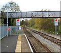
Stop signs at the NW end of Ystrad Rhondda railway station
Two stop signs with a large red spot are just beyond the end of the platforms. The text on the signs is "Start of section obtain token to Treherbert"
The section in question is the single track ahead, just beyond the bridge.
To ensure that only one train occupies this section, the driver must be in possession of the token to proceed. The token (the only one, of course!) is obtained from the driver of the train entering the station from this single-track section.
Image: © Jaggery
Taken: 28 Oct 2011
0.05 miles
7
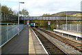
NW end of Ystrad Rhondda railway station
A southbound train from Treherbert is about to enter the station. To ensure that two trains never occupy the single track section ahead, a token system is in operation. http://www.geograph.org.uk/photo/3067202
The bridge is part of a long station access footbridge. http://www.geograph.org.uk/photo/2793362
Image: © Jaggery
Taken: 28 Oct 2011
0.05 miles
8
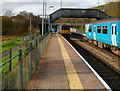
Two trains in Ystrad Rhondda railway station
There is a 270 metre long section of double track through Ystrad Rhondda station.
A few tens of metres on each side of the station, the route becomes single track.
There is a token system in operation to prevent two trains occupying a single track section at the same time. Before the northbound train on the left can proceed along the single track section to Treherbert, the driver must obtain the token from the driver of the southbound train stopped alongside the other platform. At the same time, the token for the single track section south to Porth will be exchanged.
There are prominent signs http://www.geograph.org.uk/photo/3067202 http://www.geograph.org.uk/photo/2793478 at both ends of the platforms to remind drivers of the token system.
Image: © Jaggery
Taken: 28 Oct 2011
0.05 miles
9
Leaving Gelli Industrial Estate
The road climbs away from Gelli Industrial Estate towards the B4223.
Image: © Jaggery
Taken: 3 Nov 2011
0.06 miles
10
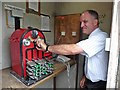
Token exchange box, Ystrad Rhondda railway station
Driver Pipien selects the single line token required for the onward journey to Treherbert.
Image: © Roger Cornfoot
Taken: 24 Aug 2017
0.08 miles