IMAGES TAKEN NEAR TO
River Street, PENTRE, CF41 7RA
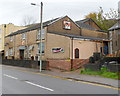
Introduction
This page details the photographs taken nearby to River Street, CF41 7RA by members of the Geograph project.
The Geograph project started in 2005 with the aim of publishing, organising and preserving representative images for every square kilometre of Great Britain, Ireland and the Isle of Man.

There are currently over 7.5m images from over14,400 individuals and you can help contribute to the project by visiting https://www.geograph.org.uk
Image Map
Images are licensed for reuse under creativecommons.org/licenses/by-sa/2.0
Notes
- Clicking on the map will re-center to the selected point.
- The higher the marker number, the further away the image location is from the centre of the postcode.
Image Listing (77 Images Found)
Images are licensed for reuse under creativecommons.org/licenses/by-sa/2.0
Image
Details
Distance
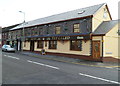
1
Ystrad Con Scooby's, Ystrad Rhondda
Pub at 51 William Street (the A4058).
There is a large poster of the cartoon dog Scooby Doo on the side wall.
Image: © Jaggery
Taken: 3 Nov 2011
0.02 miles
2
Ystrad Rhondda Rugby Football Club social club
Located at 73 William Street. This view was taken in November 2011, during the 2011-2012 rugby season, at the end of which Ystrad Rhondda Rugby Football Club won the SWALEC Division 2 East title, gaining promotion to SWALEC National League Division 1 East for the 2012-2013 season.
Image: © Jaggery
Taken: 3 Nov 2011
0.02 miles
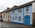
3
The Galed, Ystrad
Located on the corner of Gelligaled Road and Brook Street.
Previously coloured dark blue and named The Galed Inn, the building was given a makeover after becoming an Elite Inns pub.
Image: © Jaggery
Taken: 28 Oct 2011
0.04 miles
4
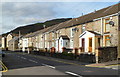
Gelligaled Road, Ystrad
Houses on the north side of the A4058, here named Gelligaled Road.
Viewed from the crossroads with Tyntyla Terrace and Cross Street.
Image: © Jaggery
Taken: 28 Oct 2011
0.04 miles
5
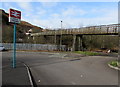
Ystrad Rhondda railway station approach
Viewed along Brook Street, south of the A4058. The long footbridge extends across the Rhondda Fawr river to Nantgwyddon Close, with a side branch to the south side of the station. Part of the station is on a bridge http://www.geograph.org.uk/photo/2793400 over the river.
Image: © Jaggery
Taken: 30 Mar 2015
0.05 miles
6
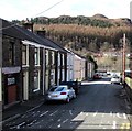
Brook Street, Ystrad
Viewed from the A4058 end looking towards Ystrad Rhondda railway station.
The left turn ahead is into Redfield Street.
Image: © Jaggery
Taken: 30 Mar 2015
0.05 miles
7
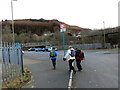
Gorsaf Reilffordd Ystrad Railway Station
Cerddwyr yn cyrraedd Gorsaf Reilffordd Ystrad.
Walkers arriving at Ystrad Railway Station.
Image: © Alan Richards
Taken: 5 Mar 2016
0.05 miles
8
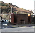
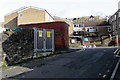
William Street urinal, Ystrad
The brick building on the corner of William Street and Brook Street is a urinal (no pedestals or wash basins). Though such facilities have largely disappeared from many parts of South Wales,
basic urinals (of varying designs) remain a common sight here in the Rhondda.
Image: © Jaggery
Taken: 30 Mar 2015
0.06 miles
9
Brook Street electricity substation, Ystrad
The Western Power Distribution electricity substation identifier is
BROOK ST (YSTRAD) S/S 541894.
Image: © Jaggery
Taken: 30 Mar 2015
0.06 miles
10

Black and white house, Ivor Street, Ystrad Rhondda
The house on the corner of Ivor Street and William Street is prosaically named
Ty Gwyn, Welsh for White House.
Image: © Jaggery
Taken: 3 Nov 2011
0.06 miles