IMAGES TAKEN NEAR TO
Ystrad Road, PENTRE, CF41 7PW
Introduction
This page details the photographs taken nearby to Ystrad Road, CF41 7PW by members of the Geograph project.
The Geograph project started in 2005 with the aim of publishing, organising and preserving representative images for every square kilometre of Great Britain, Ireland and the Isle of Man.

There are currently over 7.5m images from over14,400 individuals and you can help contribute to the project by visiting https://www.geograph.org.uk
Image Map
Images are licensed for reuse under creativecommons.org/licenses/by-sa/2.0
Notes
- Clicking on the map will re-center to the selected point.
- The higher the marker number, the further away the image location is from the centre of the postcode.
Image Listing (67 Images Found)
Images are licensed for reuse under creativecommons.org/licenses/by-sa/2.0
Image
Details
Distance
1
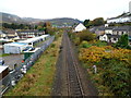
Gelli: Looking towards Ton Pentre along the Rhondda Line railway
Viewed from Tyisaf Road bridge. http://www.geograph.org.uk/photo/3066200
The next station ahead is Ton Pentre, http://www.geograph.org.uk/photo/2682992 about 700 metres ahead.
Image: © Jaggery
Taken: 3 Nov 2011
0.04 miles
2
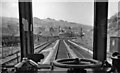
View from a DMU going up the Rhondda Valley near Ystrad
Typical colliery scene, with spoil-heaps right up the mountain. Note the four tracks, to accommodate all the coal traffic.
Image: © Ben Brooksbank
Taken: 14 Apr 1962
0.06 miles
3
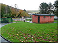
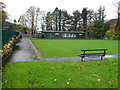
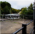
NE corner of Gelli Park, Gelli
Seen in the middle distance, a children's play area occupies this corner of Gelli Park. The so-called public conveniences in the building in the foreground were not available as the entrances were locked.
Image: © Jaggery
Taken: 3 Nov 2011
0.06 miles
4
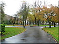
Gelli Park. Gelli
Gelli Park in early November, viewed from the Park View entrance.
The northern and western boundary of the park is the Rhondda Fawr river.
Image: © Jaggery
Taken: 3 Nov 2011
0.09 miles
5
Gelli Park bowling green, Gelli
The bowling green and pavilion occupy the northern edge of the park.
There appears to have been little if any bowling in the Rhondda before the 20th century : the first recorded instance appears to be in the summer of 1904 on the grounds of the Upper Rhondda Tennis Club, Pentre. This bowling green in Gelli Park dates from 1912.
Image: © Jaggery
Taken: 3 Nov 2011
0.10 miles
6
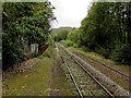
Single track railway line SE of Ton Pentre Station
The Rhondda Line viewed from the southeast end of the single platform at Ton Pentre station.
Next stop ahead is at Ystrad Rhondda station on the route to Cardiff.
Image: © Jaggery
Taken: 8 Oct 2018
0.10 miles
7
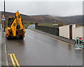
JCB, and a boundary sign facing the wrong way, Gelli
A view south along Tyisaf Road across a railway bridge. I was surprised to see on the right an Ystrad boundary sign facing me, as I thought I was leaving Ystrad and Gelli. A Google Earth Street View taken some time before this view shows the sign facing in the opposite direction, so it seems that someone has rotated the sign on the post.
Image: © Jaggery
Taken: 3 Nov 2011
0.14 miles
8
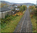
A view west along the Rhondda Line, Gelli
Viewed from this http://www.geograph.org.uk/photo/3064906 footbridge.
The next station in this direction is Ton Pentre. http://www.geograph.org.uk/photo/2682992
Image: © Jaggery
Taken: 3 Nov 2011
0.14 miles
9
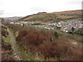
Footpath above Ton Pentre in the Rhondda Fawr valley
Image: © Gareth James
Taken: 4 Apr 2015
0.16 miles
10
Tiles Today, 65 Ystrad Road, Pentre
Viewed from Ton Pentre railway station.
Image: © Jaggery
Taken: 8 Oct 2018
0.16 miles