IMAGES TAKEN NEAR TO
Maindy Grove, PENTRE, CF41 7EY
Introduction
This page details the photographs taken nearby to Maindy Grove, CF41 7EY by members of the Geograph project.
The Geograph project started in 2005 with the aim of publishing, organising and preserving representative images for every square kilometre of Great Britain, Ireland and the Isle of Man.

There are currently over 7.5m images from over14,400 individuals and you can help contribute to the project by visiting https://www.geograph.org.uk
Image Map
Images are licensed for reuse under creativecommons.org/licenses/by-sa/2.0
Notes
- Clicking on the map will re-center to the selected point.
- The higher the marker number, the further away the image location is from the centre of the postcode.
Image Listing (83 Images Found)
Images are licensed for reuse under creativecommons.org/licenses/by-sa/2.0
Image
Details
Distance
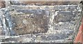
1
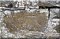
Ordnance Survey Cut Mark
This OS cut mark can be found on the wall NW side of The Parade. It marks a point 169.332m above mean sea level.
Image: © Adrian Dust
Taken: 7 May 2017
0.05 miles
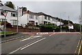
2
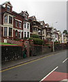
Maindy Crescent houses, Ton Pentre
Viewed across the B4223.
Image: © Jaggery
Taken: 8 Oct 2018
0.05 miles
3
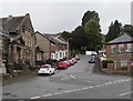
The Parade, Ton Pentre
From the B4223, The Parade ascends towards Maindy Grove.
Image: © Jaggery
Taken: 8 Oct 2018
0.07 miles
4
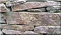
Ordnance Survey Cut Mark
This OS cut mark can be found on the wall SE side of the path. It marks a point 197.251m above mean sea level.
Image: © Adrian Dust
Taken: 7 May 2017
0.08 miles
5
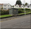
Bailey Street electricity substation, Ton Pentre
The large cabinet is a Western Power Distribution electricity substation.
Maindy Crescent houses are in the background.
Image: © Jaggery
Taken: 8 Oct 2018
0.08 miles
6
Maindy Croft, Ton Pentre
Steep dead-end street ascending from the south side of the B4223.
Image: © Jaggery
Taken: 8 Oct 2018
0.08 miles
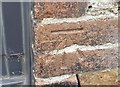
7
Ordnance Survey Cut Mark
This OS cut mark can be found on No31 Bailey Street. It marks a point 152.156m above mean sea level.
Image: © Adrian Dust
Taken: 7 May 2017
0.08 miles
8
Ordnance Survey Cut Mark
This OS cut mark can be found on the converted barn at Maindy Farm. It marks a point 187.958m above mean sea level.
Image: © Adrian Dust
Taken: 7 May 2017
0.08 miles
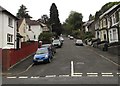
9
Junction of Bailey Street and Maindy Road, Ton Pentre
Bailey Street ascends to the B4223 Maindy Road.
The 20mph speed limit on Bailey Street increases to 30mph.
Image: © Jaggery
Taken: 8 Oct 2018
0.08 miles
10
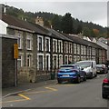
Row of houses and cars, Bailey Street, Ton Pentre
The zigzag yellow markings are part of the Keep Clear Zone outside Ton Pentre Junior School. https://www.geograph.org.uk/photo/5933223
Image: © Jaggery
Taken: 8 Oct 2018
0.09 miles