IMAGES TAKEN NEAR TO
Bailey Street, PENTRE, CF41 7EL
Introduction
This page details the photographs taken nearby to Bailey Street, CF41 7EL by members of the Geograph project.
The Geograph project started in 2005 with the aim of publishing, organising and preserving representative images for every square kilometre of Great Britain, Ireland and the Isle of Man.

There are currently over 7.5m images from over14,400 individuals and you can help contribute to the project by visiting https://www.geograph.org.uk
Image Map
Images are licensed for reuse under creativecommons.org/licenses/by-sa/2.0
Notes
- Clicking on the map will re-center to the selected point.
- The higher the marker number, the further away the image location is from the centre of the postcode.
Image Listing (163 Images Found)
Images are licensed for reuse under creativecommons.org/licenses/by-sa/2.0
Image
Details
Distance
1
Bailey Street speed bumps, Ton Pentre
On the approach to Ton Pentre Junior School. https://www.geograph.org.uk/photo/5933223
Image: © Jaggery
Taken: 8 Oct 2018
0.00 miles
2
Warning sign - School/Ysgol, Bailey Street, Ton Pentre
The English/Welsh sign is on the approach to Ton Pentre Junior School. https://www.geograph.org.uk/photo/5933223
Image: © Jaggery
Taken: 8 Oct 2018
0.01 miles
3
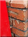
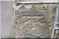
Ordnance Survey Cut Mark
This OS cut mark can be found on the east angle of the school. It marks a point 153.522m above mean sea level.
Image: © Adrian Dust
Taken: 7 May 2017
0.02 miles
4
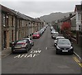
Bailey Street, Ton Pentre
Looking to the SE along Bailey Street past speed bumps.
Church Road and Church Street are ahead.
Image: © Jaggery
Taken: 8 Oct 2018
0.02 miles
5
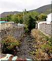
North along Nant Ian, Ton Pentre
Nant Ian flows away from Bailey Street towards the Rhondda Fawr river about 70 metres from the camera.
Image: © Jaggery
Taken: 8 Oct 2018
0.03 miles
6
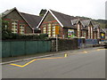
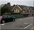
Ton Pentre Junior School
Viewed across Bailey Street in Ton Pentre.
Image: © Jaggery
Taken: 8 Oct 2018
0.03 miles
7
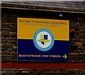
Welcome to Ton Pentre Junior School
On the wall on the right here. https://www.geograph.org.uk/photo/5933223 The text is also in Welsh.
Image: © Jaggery
Taken: 8 Oct 2018
0.03 miles
8
Ordnance Survey Cut Mark
This OS cut mark can be found on No1 Maindy Road. It marks a point 153.439m above mean sea level.
Image: © Adrian Dust
Taken: 7 May 2017
0.03 miles
9
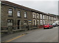
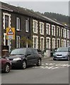
Row of stone houses, Bailey Street, Ton Pentre
This part of Bailey Street is between Queen Street and Augusta Street.
Image: © Jaggery
Taken: 8 Oct 2018
0.04 miles
10
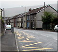
Zigzag yellow markings on the B4223, Ton Pentre
Marking the Keep Clear Zone outside Ton Pentre Junior School.
Image: © Jaggery
Taken: 8 Oct 2018
0.04 miles