IMAGES TAKEN NEAR TO
Queen Street, PENTRE, CF41 7EJ
Introduction
This page details the photographs taken nearby to Queen Street, CF41 7EJ by members of the Geograph project.
The Geograph project started in 2005 with the aim of publishing, organising and preserving representative images for every square kilometre of Great Britain, Ireland and the Isle of Man.

There are currently over 7.5m images from over14,400 individuals and you can help contribute to the project by visiting https://www.geograph.org.uk
Image Map
Images are licensed for reuse under creativecommons.org/licenses/by-sa/2.0
Notes
- Clicking on the map will re-center to the selected point.
- The higher the marker number, the further away the image location is from the centre of the postcode.
Image Listing (160 Images Found)
Images are licensed for reuse under creativecommons.org/licenses/by-sa/2.0
Image
Details
Distance
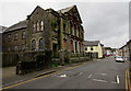
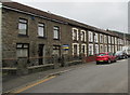
1
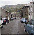
Queen Street, Ton Pentre
From Maindy Road along Queen Street towards Bailey Street.
Image: © Jaggery
Taken: 8 Oct 2018
0.01 miles
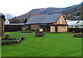
2
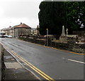
Churchyard and houses, Bailey Street, Ton Pentre
The edge of St John the Baptist churchyard and Bailey Street houses viewed from the corner of Church Road.
Image: © Jaggery
Taken: 8 Oct 2018
0.01 miles
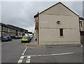
3
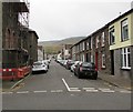
Queen Street, Ton Pentre
From Bailey Street along Queen Street towards Pryce Street.
Image: © Jaggery
Taken: 8 Oct 2018
0.02 miles
4
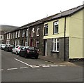
On-street parking, Queen Street, Ton Pentre
This part of Queen Street is between Bailey Street and Pryce Street.
Image: © Jaggery
Taken: 8 Oct 2018
0.02 miles
5
St John the Baptist, Ton Pentre
This is the Bailey Street side of the Parish Church of St John the Baptist, in the Church in Wales diocese of Llandaff, benefice of Ystradyfodwg. The modern single-storey church replaced the Victorian-era church of the same name on this site.
Image: © Jaggery
Taken: 3 Nov 2011
0.02 miles
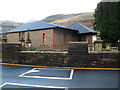
6
St John the Baptist church hall, Ton Pentre
Located in the NE corner of the churchyard. An edge of the Church in Wales church http://www.geograph.org.uk/photo/2679140 is on the left.
Image: © Jaggery
Taken: 3 Nov 2011
0.02 miles
7
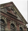
Welsh inscription on the former Bethesda chapel, Ton Pentre
The Welsh text on this https://www.geograph.org.uk/photo/6041154 derelict building records that it was built in 1877, rebuilt in 1906.
Image: © Jaggery
Taken: 8 Oct 2018
0.02 miles
8
Bailey Street speed bumps, Ton Pentre
Near the former Bethesda Chapel https://www.geograph.org.uk/photo/2679021 which has been derelict for about 30 years.
Image: © Jaggery
Taken: 8 Oct 2018
0.03 miles
9
Row of stone houses, Bailey Street, Ton Pentre
This part of Bailey Street is between Queen Street and Augusta Street.
Image: © Jaggery
Taken: 8 Oct 2018
0.03 miles
10
Junction of Augusta Street and Bailey Street, Ton Pentre
Augusta Street from the right (northeast) joins Bailey Street.
Image: © Jaggery
Taken: 8 Oct 2018
0.03 miles