IMAGES TAKEN NEAR TO
Brithweunydd Road, TONYPANDY, CF40 2UQ
Introduction
This page details the photographs taken nearby to Brithweunydd Road, CF40 2UQ by members of the Geograph project.
The Geograph project started in 2005 with the aim of publishing, organising and preserving representative images for every square kilometre of Great Britain, Ireland and the Isle of Man.

There are currently over 7.5m images from over14,400 individuals and you can help contribute to the project by visiting https://www.geograph.org.uk
Image Map
Images are licensed for reuse under creativecommons.org/licenses/by-sa/2.0
Notes
- Clicking on the map will re-center to the selected point.
- The higher the marker number, the further away the image location is from the centre of the postcode.
Image Listing (61 Images Found)
Images are licensed for reuse under creativecommons.org/licenses/by-sa/2.0
Image
Details
Distance
1
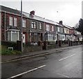
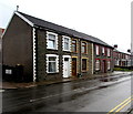
Brithweunydd Road houses east of Davies Close, Trealaw
The Davies Close name sign is on the left.
Image: © Jaggery
Taken: 10 Oct 2017
0.01 miles
2
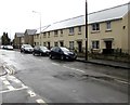
Modern houses on the south side of Brithweunydd Road, Trealaw
Viewed from the corner of Davies Close looking across Brithweunydd Road towards the corner of Stryd Newydd.
Image: © Jaggery
Taken: 10 Oct 2017
0.02 miles
3
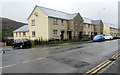
Corner of Brithweunydd Road and Stryd Newydd, Trealaw
Modern houses viewed across the B4278 Brithweunydd Road.
Stryd Newydd is Welsh for New Street. The name sign on the corner is in Welsh only.
Image: © Jaggery
Taken: 10 Oct 2017
0.02 miles
4
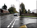
Junction of Stryd Newydd and Brithweunydd Road, Trealaw
From the right, Stryd Newydd joins the B4278 Brithweunydd Road.
Image: © Jaggery
Taken: 10 Oct 2017
0.02 miles
5
Three houses on the north side of Brithweunydd Road, Trealaw
At first glance, I thought this was a row of three houses, but I was wrong.
Two semi-detached houses are on the camera side - the corner of Cairo Street is on the left. http://www.geograph.org.uk/photo/5566952
A detached house is on the right, on the corner of Davies Close. http://www.geograph.org.uk/photo/5566954
Image: © Jaggery
Taken: 10 Oct 2017
0.03 miles
6
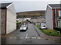
Davies Close, Trealaw
Dead-end street on the north side of Brithweunydd Road.
Image: © Jaggery
Taken: 10 Oct 2017
0.04 miles
7
Stryd Newydd, Trealaw
Cul-de-sac of modern houses on the south side of Brithweunydd Road.
Stryd Newydd is Welsh for New Street. The nearby name sign is in Welsh only.
Image: © Jaggery
Taken: 10 Oct 2017
0.04 miles
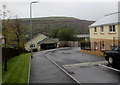
8
Entrance to Carnegie Clinic, Trealaw
Medical clinic entrance from the south side of Brithweunydd Road opposite Trealaw Cemetery.
Image: © Jaggery
Taken: 10 Oct 2017
0.04 miles
9
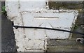
Ordnance Survey Cut Mark
This OS cut mark can be found on No146 Brithweunydd Road. It marks a point 154.671m above mean sea level.
Image: © Adrian Dust
Taken: 21 May 2017
0.04 miles
10
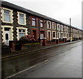
Long row of houses, Brithweunydd Road, Trealaw
On the north side of the B4278 Brithweunydd Road between Alaw Road and Cairo Street (out of shot ahead).
Image: © Jaggery
Taken: 10 Oct 2017
0.05 miles