IMAGES TAKEN NEAR TO
Brithweunydd Road, TONYPANDY, CF40 2UD
Introduction
This page details the photographs taken nearby to Brithweunydd Road, CF40 2UD by members of the Geograph project.
The Geograph project started in 2005 with the aim of publishing, organising and preserving representative images for every square kilometre of Great Britain, Ireland and the Isle of Man.

There are currently over 7.5m images from over14,400 individuals and you can help contribute to the project by visiting https://www.geograph.org.uk
Image Map
Images are licensed for reuse under creativecommons.org/licenses/by-sa/2.0
Notes
- Clicking on the map will re-center to the selected point.
- The higher the marker number, the further away the image location is from the centre of the postcode.
Image Listing (125 Images Found)
Images are licensed for reuse under creativecommons.org/licenses/by-sa/2.0
Image
Details
Distance
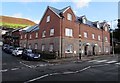
1
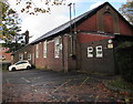
Maes-yr-Haf Centre, Trealaw
Community centre set back from the north side of the B4278 Brithweunydd Road.
Image: © Jaggery
Taken: 28 Sep 2017
0.02 miles
2
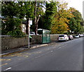
Brithweunydd Road bus stop and shelter, Trealaw
This stop for buses to Porth.
Image: © Jaggery
Taken: 28 Sep 2017
0.02 miles
3
Royal Hotel electricity substation, Trealaw
Viewed across the B4278 Brithweunydd Road. The Western Power Distribution electricity substation identifier is ROYAL HOTEL TREALAW S/S 541878. When the substation was installed, the building on the left was the Royal Hotel, http://www.geograph.org.uk/photo/958534 now demolished. Flats http://www.geograph.org.uk/photo/5554038 now occupy the site.
Image: © Jaggery
Taken: 28 Sep 2017
0.02 miles
4
Tree-lined Clydach Court, Trealaw
Care home set back from the north side of Brithweunydd Road.
Image: © Jaggery
Taken: 28 Sep 2017
0.03 miles
5
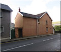
Maelog Villa, Trealaw
Scantily windowed house on the south side of the B4278 Brithweunydd Road.
Image: © Jaggery
Taken: 28 Sep 2017
0.03 miles
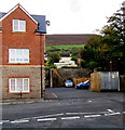
6
Recently-built flats in Trealaw
The Brithweunydd Road side of flats on the corner of Royal Terrace on the site formerly occupied by the Royal Hotel, seen here http://www.geograph.org.uk/photo/958534 in 2008.
Image: © Jaggery
Taken: 28 Sep 2017
0.03 miles
7
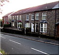
Station Road houses, Trealaw
On the descent from Brithweunydd Road towards Dinas Rhondda railway station. https://www.geograph.org.uk/photo/5553175
Image: © Jaggery
Taken: 28 Sep 2017
0.03 miles
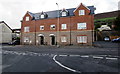
8
Modern flats on a Trealaw corner
Built in the second decade of the 21st century on the corner of Brithweunydd Road and Royal Terrace.
This site was formerly occupied by the Royal Hotel, seen here http://www.geograph.org.uk/photo/958534 in 2008.
Image: © Jaggery
Taken: 28 Sep 2017
0.03 miles
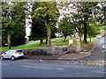
9
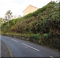
Steep bank above Station Road, Trealaw
Looking towards the edge of a house on the south side of Brithweunydd Road.
Image: © Jaggery
Taken: 28 Sep 2017
0.04 miles
10
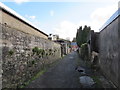
East along a Trealaw back lane
Extending for 70 metres from Maesyffynon Terrace to Royal Terrace.
Image: © Jaggery
Taken: 28 Sep 2017
0.04 miles