1
Footpath towards Bridge Street, Tonypandy
Viewed from the western end of this http://www.geograph.org.uk/photo/5565539 footbridge.
Image: © Jaggery
Taken: 10 Oct 2017
0.01 miles
2
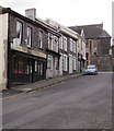
Taliesin Residential Home for the Elderly, Tonypandy
At the northeast end of Bridge Street, above the Rhondda River.
Image: © Jaggery
Taken: 17 Oct 2017
0.01 miles
3
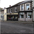
The Eye Centre, Tonypandy
Opticians at 6 Bridge Street. The car is parked near the corner of Dunraven Street.
Image: © Jaggery
Taken: 20 Oct 2017
0.01 miles
4
Bridge Street gas installation, Tonypandy
Located above the Rhondda River, the Wales & West Utilities gas installation is in a locked green enclosure.
Image: © Jaggery
Taken: 17 Oct 2017
0.01 miles
5
Back lane in Tonypandy
On the southeast side of Bridge Street.
Image: © Jaggery
Taken: 20 Oct 2017
0.01 miles
6
The Eye Centre, Tonypandy
Opticians at 6 Bridge Street. Taliesin Residential Home for the Elderly http://www.geograph.org.uk/photo/5571584 is on the left.
Image: © Jaggery
Taken: 20 Oct 2017
0.02 miles
7
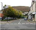
Bridge Street, Tonypandy
Dead-end street descending from Dunraven Street towards the Rhondda River.
Image: © Jaggery
Taken: 17 Oct 2017
0.02 miles
8
Steps up to a footbridge, Tonypandy Railway Station
Viewed from the NW edge of the only platform at the station,on the Rhondda Line.
Image: © Jaggery
Taken: 28 Oct 2011
0.02 miles
9
Judge's Bingo Hall, Tonypandy
Located on Trealaw Road, close to the railway station.
The building was opened in July 1909 by the Duke of Argyll and Princess Louise. It was originally called The Judge Williams Memorial Hall, a gift to the town from Lt. Col. Sir Rhys Williams.
Image: © Jaggery
Taken: 28 Oct 2011
0.02 miles
10
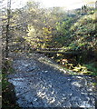
Pipe bridge across the Rhondda Fawr, Tonypandy
During most of the previous months of 2011, and in much of 2010, the Rhondda Fawr was relatively tranquil, but this view of its swirling waters taken on Friday October 28th 2011 shows the result of many hours of rain in South Wales the previous day.
Image: © Jaggery
Taken: 28 Oct 2011
0.02 miles


