1
Ordnance Survey Cut Mark
This OS cut mark can be found on the SE buttress of the bridge. It marks a point 139.199m above mean sea level.
Image: © Adrian Dust
Taken: 7 May 2017
0.03 miles
2
View towards Llwynypia from the south of Penrhys
Viewed from a rough track 180 metres south of the B4512 Penrhys Road in Penrhys.
Image: © Jaggery
Taken: 30 Mar 2015
0.05 miles
3
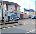
Kings Garden, Llwynypia
Chinese (Peking and Cantonese cuisine) takeaway at 145 Tyntyla Road.
Image: © Jaggery
Taken: 28 Oct 2011
0.06 miles
4
Entrance to Ysbyty Cwm Rhondda hospital, Llwynypia
View across Partridge Road. Ysbyty Cwm Rhondda is a new 108-bed community hospital with an integrated primary care centre. It has replaced the now-demolished old hospital on the opposite side of Partridge Road. The new hospital has four 27-bed rehabilitation wards plus departments for treating minor injuries, radiology, pharmacy, therapies and outpatients.
Image: © Jaggery
Taken: 28 Oct 2011
0.08 miles
5
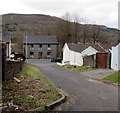
Lane descends to Partridge Road, Llwynypia
Behind the camera is the bottom of a long steep hillside up to Penrhys.
Image: © Jaggery
Taken: 30 Mar 2015
0.08 miles
6
White van and dark green bus shelter in Llwynypia
The Rhondda Garden Maintenance & Landscaping Service van is parked near a Partridge Road bus shelter.
Image: © Jaggery
Taken: 30 Mar 2015
0.09 miles
7
Ysbyty Cwm Rhondda, Llwynypia
View across Partridge Road. Ysbyty Cwm Rhondda (Cwm Rhondda Hospital) is a modern 108-bed community hospital (opened in early 2010) with an integrated primary care centre. It replaced the old hospital formerly on the opposite side of Partridge Road. This hospital has four 27-bed rehabilitation wards plus departments for treating minor injuries, radiology, pharmacy, therapies and outpatients.
Image: © Jaggery
Taken: 30 Mar 2015
0.09 miles
8
Change of house type in Llwynypia
On the west side of the A4058 Partridge Road.
Image: © Jaggery
Taken: 30 Mar 2015
0.10 miles
9
Kings Garden, Llwynypia
Peking and Cantonese cuisine takeaway at 145 Tyntyla Road, on the corner of Sherwood Street.
Image: © Jaggery
Taken: 30 Mar 2015
0.10 miles
10
Lane at the foot of a hillside, Llwynypia
The lane is between a long steep descent from Penrhys, and the backs of Partridge Road houses.
Image: © Jaggery
Taken: 30 Mar 2015
0.11 miles


