IMAGES TAKEN NEAR TO
Station Road, TONYPANDY, CF40 2PL
Introduction
This page details the photographs taken nearby to Station Road, CF40 2PL by members of the Geograph project.
The Geograph project started in 2005 with the aim of publishing, organising and preserving representative images for every square kilometre of Great Britain, Ireland and the Isle of Man.

There are currently over 7.5m images from over14,400 individuals and you can help contribute to the project by visiting https://www.geograph.org.uk
Image Map
Images are licensed for reuse under creativecommons.org/licenses/by-sa/2.0
Notes
- Clicking on the map will re-center to the selected point.
- The higher the marker number, the further away the image location is from the centre of the postcode.
Image Listing (137 Images Found)
Images are licensed for reuse under creativecommons.org/licenses/by-sa/2.0
Image
Details
Distance
1
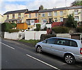
Squires Row houses, Trealaw
Above Station Road.
Image: © Jaggery
Taken: 28 Sep 2017
0.01 miles
2
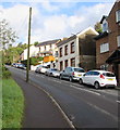
On-street parking, Station Road, Trealaw
On the ascent from Dinas Rhondda railway station towards Brithweunydd Road.
Image: © Jaggery
Taken: 28 Sep 2017
0.02 miles
3
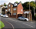
Ty Lily Mia Guest House, Station Road, Trealaw
The guesthouse near Dinas Rhondda railway station http://www.geograph.org.uk/photo/5553164 is named after the owners' daughters Lily and Mia.
Image: © Jaggery
Taken: 28 Sep 2017
0.03 miles
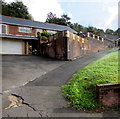
4
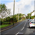
Up Station Road, Trealaw
Part of the ascent of Station Road from Dinas Rhondda railway station to Brithweunydd Road.
Image: © Jaggery
Taken: 28 Sep 2017
0.04 miles
5
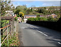
Station Road river and railway bridge, Dinas
The bridge carries Station Road over the Rhondda River
and the Rhondda Line railway near Dinas Rhondda railway station.
Image: © Jaggery
Taken: 17 Oct 2017
0.04 miles
6
Bryn Dinas View, Trealaw
Dead-end road descending from the south side of Brithweunydd Road.
Image: © Jaggery
Taken: 28 Sep 2017
0.05 miles
7
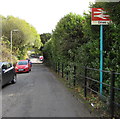
Dinas railway station name sign
The sign shows Dinas whereas signs on the station show Dinas Rhondda http://www.geograph.org.uk/photo/5553164 to distinguish this Dinas from Dinas Powys.
Image: © Jaggery
Taken: 17 Oct 2017
0.05 miles
8
Station Road bridge west of Dinas Rhondda railway station
Viewed from the station platform. The bridge carrying Station Road over
the single-track Rhondda Line also carries Station Road over the Rhondda River.
Image: © Jaggery
Taken: 28 Sep 2017
0.05 miles
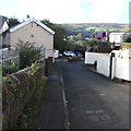
9
Path ascending from Station Road, Trealaw
Near Dinas Rhondda railway station.
Image: © Jaggery
Taken: 28 Sep 2017
0.05 miles
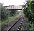
10
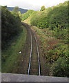
Rhondda Line west towards Tonypandy station
Viewed from this bridge http://www.geograph.org.uk/photo/5553250 near Dinas Rhondda station.
Image: © Jaggery
Taken: 28 Sep 2017
0.06 miles