1
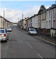
North along Trealaw Road, Trealaw
Towards Ynyscynon Road and Llwynypia.
Image: © Jaggery
Taken: 28 Sep 2017
0.06 miles
2
Ordnance Survey Cut Mark
This OS cut mark can be found on No213 Trealaw Road. It marks a point 414.385m above mean sea level.
Image: © Adrian Dust
Taken: 13 May 2017
0.08 miles
3
Ordnance Survey Cut Mark
This OS cut mark can be found on No179 Trealaw Road. It marks a point 125.974m above mean sea level.
Image: © Adrian Dust
Taken: 13 May 2017
0.09 miles
4
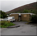
Tonypandy Health Centre
National Health Service centre located in De Winton Field.
Image: © Jaggery
Taken: 21 Sep 2017
0.11 miles
5
Trottsco office, De Winton Fields, Tonypandy
Roofing and scaffolding business.
Image: © Jaggery
Taken: 21 Sep 2017
0.11 miles
6
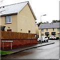
Caeau De Winton houses, Tonypandy
Caeau is Welsh for fields. De usually means south in Welsh, but not here.
The De Winton family of Brecon were formerly major landowners in the Rhondda.
De Winton Street and the De Winton pub http://www.geograph.org.uk/photo/5551351 are nearby.
Image: © Jaggery
Taken: 21 Sep 2017
0.11 miles
7
Welsh-only name sign, Caeau De Winton, Tonypandy
Caeau is Welsh for fields. De usually means south in Welsh, but not here.
The De Winton family of Brecon were formerly major landowners in the Rhondda.
De Winton Street and the De Winton pub http://www.geograph.org.uk/photo/5551351 are nearby.
Image: © Jaggery
Taken: 21 Sep 2017
0.12 miles
8
Anderson Terrace, Tonypandy
A row of four houses on the north side of St Andrew's Church.
Image: © Jaggery
Taken: 21 Sep 2017
0.12 miles
9
Richards Terrace Tonypandy
Row of houses extending for 50 metres.
Image: © Jaggery
Taken: 21 Sep 2017
0.14 miles
10
Row of houses near a bend in Miskin Road, Trealaw
Image: © Jaggery
Taken: 28 Sep 2017
0.14 miles


