IMAGES TAKEN NEAR TO
Trealaw Road, TONYPANDY, CF40 2NR
Introduction
This page details the photographs taken nearby to Trealaw Road, CF40 2NR by members of the Geograph project.
The Geograph project started in 2005 with the aim of publishing, organising and preserving representative images for every square kilometre of Great Britain, Ireland and the Isle of Man.

There are currently over 7.5m images from over14,400 individuals and you can help contribute to the project by visiting https://www.geograph.org.uk
Image Map
Images are licensed for reuse under creativecommons.org/licenses/by-sa/2.0
Notes
- Clicking on the map will re-center to the selected point.
- The higher the marker number, the further away the image location is from the centre of the postcode.
Image Listing (191 Images Found)
Images are licensed for reuse under creativecommons.org/licenses/by-sa/2.0
Image
Details
Distance
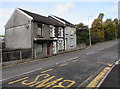
1
Distinctive row of houses, Trealaw Road, Trealaw
With projecting first floor windows. The name CLOS YNYSYGRUG is on the side wall.
Image: © Jaggery
Taken: 28 Sep 2017
0.01 miles
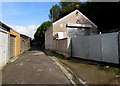
2
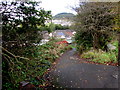
Side road descending from Miskin Road, Trealaw
This way to Trealaw Road.
Image: © Jaggery
Taken: 28 Sep 2017
0.02 miles
3
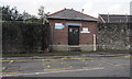
Trealaw Pumping Station
Welsh Water site alongside Trealaw Road.
Image: © Jaggery
Taken: 28 Sep 2017
0.02 miles
5
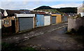
Back lane lockup garages, Trealaw
The back lane is between Miskin Road and Trealaw Road.
Image: © Jaggery
Taken: 28 Sep 2017
0.03 miles
6
Belmont stone cleaning premises, Trealaw
Viewed across a back lane between Miskin Road and Trealaw Road.
Image: © Jaggery
Taken: 28 Sep 2017
0.03 miles
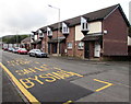
8
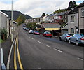
On-street parking, Miskin Road, Trealaw
On-street parking on the right side of the road.
Double yellow lines on the left indicate no parking at any time.
Image: © Jaggery
Taken: 28 Sep 2017
0.04 miles
9
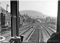
Approaching Tonypandy from Treherbert, on a DMU 1962
View southward, towards Tonypandy (& Trealaw - until 5/73) down the Rhondda Fawr valley from Treherbert, on a DMU for Cardiff via Abercynon and Pontypridd. The DMUs had then only recently taken over from the Steam 0-6-2Ts on the local passenger services and were welcome to Train-Spotters for the view ahead you might share with the driver. Moreover, many of the coal-mines were still active and the coal traffic remained intensive - and worked by Steam locomotives for a few more years.
Image: © Ben Brooksbank
Taken: 14 Apr 1962
0.04 miles
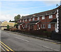
10
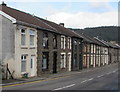
West side of Miskin Road, Trealaw
Row of houses extending for about 100 metres.
Image: © Jaggery
Taken: 28 Sep 2017
0.04 miles