1
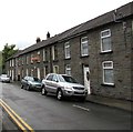
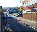
Houses on the east side of Gilmour Street, Tonypandy
Looking north from the corner of Church Street.
Image: © Jaggery
Taken: 21 Sep 2017
0.02 miles
2
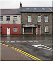
Tonypandy Methodist Church
Part of the Mid Glamorgan Mission Methodist Circuit, viewed across Llwynypia Road in September 2017.
Image: © Jaggery
Taken: 21 Sep 2017
0.03 miles
3
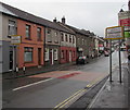
It's Magic in Tonypandy
The television and other audiovisual equipment sales and repairs shop
at 6 Llwynypia Road is closed and shuttered at 10am on a Thursday.
Image: © Jaggery
Taken: 21 Sep 2017
0.03 miles
4
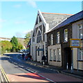
Croeso i/ Welcome to / Tonypandy
The signs alongside Llwynypia Road face Llwynypia.
The Llwynypia signs http://www.geograph.org.uk/photo/5544999 are on the backs of these signs.
Image: © Jaggery
Taken: 21 Sep 2017
0.03 miles
5
Croeso i/ Welcome to / Llwynypia
The signs alongside Llwynypia Road face Tonypandy.
The Tonypandy signs http://www.geograph.org.uk/photo/5544987 are on the backs of these signs.
Image: © Jaggery
Taken: 21 Sep 2017
0.03 miles
6
East side of Llwynypia Road, Tonypandy
Houses, shops and, on the left, Tonypandy Methodist Church. http://www.geograph.org.uk/photo/5544942
Image: © Jaggery
Taken: 21 Sep 2017
0.04 miles
7
Southern boundary of Llwynypia
Viewed from Tonypandy, Llwynypia Road reaches the southern edge of Llwynypia, population 2,253 (2001 UK Census). Llwynypia is Welsh for magpie's grove or magpie's bush, from the name of a farm that once existed hereabouts.
At centre right is Tonypandy Methodist Church http://www.geograph.org.uk/photo/2675965 built in 1873 as Zion Primitive Methodist.
Image: © Jaggery
Taken: 28 Oct 2011
0.04 miles
8
Tonypandy Methodist Church, Llwynypia
Located on the east side of Llwynypia Road, Llwynypia, a few metres north of the Tonypandy boundary. The name on the north side of the church is Tonypandy Methodist Church. Inscribed in stone on the front on the church is Zion Primitive Methodist built 1873 rebuilt 1915.
Image: © Jaggery
Taken: 28 Oct 2011
0.04 miles
9
Home Bargains, Llwynypia
Located on the east side of Llwynypia Road, immediately north of Tonypandy Methodist Church. http://www.geograph.org.uk/photo/2675965
TJ Morris Ltd, trading as Home Bargains, is one of the UK's fastest growing discount retailers. In early 2011, there were more than 200 of its stores in the UK. The firm's expansion target is for at least 500 stores by 2018. Previous retail occupiers of the premises include Aldi and Kwik Save.
Image: © Jaggery
Taken: 28 Oct 2011
0.04 miles
10
Northern boundary of Tonypandy
Viewed from Llwynypia along Llwynypia Road. The green building in the middle distance is The Pandy. http://www.geograph.org.uk/photo/2674608
Image: © Jaggery
Taken: 28 Oct 2011
0.04 miles


