IMAGES TAKEN NEAR TO
The Chandlery, TONYPANDY, CF40 2NH
Introduction
This page details the photographs taken nearby to The Chandlery, CF40 2NH by members of the Geograph project.
The Geograph project started in 2005 with the aim of publishing, organising and preserving representative images for every square kilometre of Great Britain, Ireland and the Isle of Man.

There are currently over 7.5m images from over14,400 individuals and you can help contribute to the project by visiting https://www.geograph.org.uk
Image Map
Images are licensed for reuse under creativecommons.org/licenses/by-sa/2.0
Notes
- Clicking on the map will re-center to the selected point.
- The higher the marker number, the further away the image location is from the centre of the postcode.
Image Listing (48 Images Found)
Images are licensed for reuse under creativecommons.org/licenses/by-sa/2.0
Image
Details
Distance
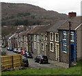
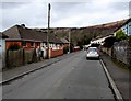
1

Williams Street, Llwynypia
Williams Street ascends past the Church Street junction on the right.
Image: © Jaggery
Taken: 30 Mar 2015
0.02 miles
2
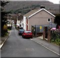
Williams Street electricity substation, Llwynypia
The Western Power Distribution identifier on the electricity substation to the right of the red car is S/S 541886.
Image: © Jaggery
Taken: 30 Mar 2015
0.02 miles
3
Williams Street, Llwynypia
Williams Street descends towards a four-road junction.
Image: © Jaggery
Taken: 30 Mar 2015
0.03 miles
4
No Motor Vehicles Except for Access sign, Llwynypia
On the corner of Mountain View, at the top of a descent past the backs of Williams Street houses.
The roadway narrows ahead. http://www.geograph.org.uk/photo/4407143
Image: © Jaggery
Taken: 30 Mar 2015
0.04 miles
5
Houses at the northern end of Mountain View, Llwynypia
Row of four houses.
Image: © Jaggery
Taken: 30 Mar 2015
0.04 miles
6
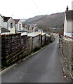
Narrow lane, Llwynypia
Past the backs of Williams Street houses.
A sign behind the camera indicates that this is not a route for motor vehicles, except for access.
Image: © Jaggery
Taken: 30 Mar 2015
0.04 miles
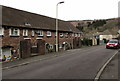
7
Houses set above the Mountain View roadway, Llwynypia
These houses on the east side of Mountain View are set a couple of metres above road level,
opposite houses on the west side http://www.geograph.org.uk/photo/4407041 which are set below road level.
Image: © Jaggery
Taken: 30 Mar 2015
0.06 miles
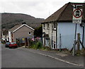
8
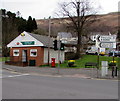
Partridge Square post office, Llwynypia
Village post office viewed across the A4058 Partridge Road, three miles from Treorchy.
Image: © Jaggery
Taken: 30 Mar 2015
0.06 miles
9
Mountain View houses set below road level, Llwynypia
Steps lead down from the roadway to these houses.
The houses on the opposite side http://www.geograph.org.uk/photo/4407496 are set a couple of metres above road level.
Image: © Jaggery
Taken: 30 Mar 2015
0.06 miles
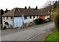
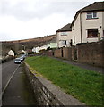
10
Harcombe Road houses at different levels, Llwynypia
Houses on the left (west) side are set a couple of metres lower than houses on the opposite side of the road.
Image: © Jaggery
Taken: 30 Mar 2015
0.07 miles