IMAGES TAKEN NEAR TO
Church Street, TONYPANDY, CF40 2ND
Introduction
This page details the photographs taken nearby to Church Street, CF40 2ND by members of the Geograph project.
The Geograph project started in 2005 with the aim of publishing, organising and preserving representative images for every square kilometre of Great Britain, Ireland and the Isle of Man.

There are currently over 7.5m images from over14,400 individuals and you can help contribute to the project by visiting https://www.geograph.org.uk
Image Map
Images are licensed for reuse under creativecommons.org/licenses/by-sa/2.0
Notes
- Clicking on the map will re-center to the selected point.
- The higher the marker number, the further away the image location is from the centre of the postcode.
Image Listing (73 Images Found)
Images are licensed for reuse under creativecommons.org/licenses/by-sa/2.0
Image
Details
Distance
1
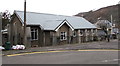
North side of St Cynon's church, Llwynypia
Part of the Church in Wales Parish of Trealaw with Ystrad Rhondda
with Ynyscynon in the Benefice of Pont Rhondda, Diocese of Llandaff.
Image: © Jaggery
Taken: 30 Mar 2015
0.03 miles
2
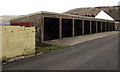
Ten lockup garages, Mountain View, Llwynypia
Extending for nearly 30 metres along the western edge of Mountain View.
Image: © Jaggery
Taken: 30 Mar 2015
0.03 miles
3
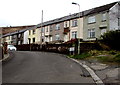
Mountain View houses set below road level, Llwynypia
Steps lead down from the roadway to these houses.
The houses on the opposite side http://www.geograph.org.uk/photo/4407496 are set a couple of metres above road level.
Image: © Jaggery
Taken: 30 Mar 2015
0.03 miles
4
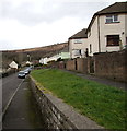
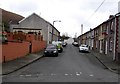
Houses set above the Mountain View roadway, Llwynypia
These houses on the east side of Mountain View are set a couple of metres above road level,
opposite houses on the west side http://www.geograph.org.uk/photo/4407041 which are set below road level.
Image: © Jaggery
Taken: 30 Mar 2015
0.04 miles
5
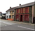
Building derelict for many years, Partridge Road, Llwynypia
Number 100 Partridge Road viewed in late March 2015.
The Rhondda Cynon Taf council website shows a document registered in April 2004
applying for the demolition and rebuild of 100 Partridge Road.
Image: © Jaggery
Taken: 30 Mar 2015
0.04 miles
6
Mountain View houses, Llwynypia
The name sign shows that Mountain View leads to Harcombe Road.
Image: © Jaggery
Taken: 30 Mar 2015
0.04 miles
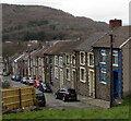
7
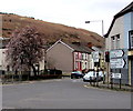
Church Street, Llwynypia
Looking south from Williams Street along Church Street towards Mountain View.
Image: © Jaggery
Taken: 30 Mar 2015
0.05 miles
8
Distances from Llwynypia
The sign at the edge of a major junction shows 6 (miles) to Pontypridd,
3 to Porth as well as other locations via the A4058.
Confusingly, the sign on the left side of the traffic lights also
shows the A4058, but it is pointing to the B4278 towards Trealaw.
Image: © Jaggery
Taken: 30 Mar 2015
0.05 miles
9
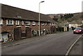
Williams Street, Llwynypia
Williams Street descends towards a four-road junction.
Image: © Jaggery
Taken: 30 Mar 2015
0.05 miles
10
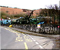
Old vehicles view, Mountain View, Llwynypia
The street is named Mountain View, but the foreground view here
is a fenced yard of old vehicles and parts, with a hillside backdrop.
Image: © Jaggery
Taken: 30 Mar 2015
0.05 miles