1
St Cynon's church, Llwynypia
Located in Partridge Square, at the crossroads of Princess Louise Road, Partridge Road (north and south sections) and Williams Street. The Church in Wales church is in the parish of Trealaw with Ystrad Rhondda with Ynyscynon in the benefice of Pont Rhondda, diocese of Llandaff.
Image: © Jaggery
Taken: 28 Oct 2011
0.03 miles
2
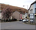
Towards Partridge Road, Llwynypia
Down towards the B4278 Partridge Road from the corner of Mountain View and Church Street.
Image: © Jaggery
Taken: 30 Mar 2015
0.04 miles
3
Rhondda Fawr river bends away from Princess Louise Road, Llwynypia
The Rhondda Fawr flows away from the bridge carrying the A4058, here named Princess Louise Road, over the river.
Image: © Jaggery
Taken: 28 Oct 2011
0.06 miles
4
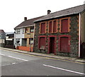
Building derelict for many years, Partridge Road, Llwynypia
Number 100 Partridge Road viewed in late March 2015.
The Rhondda Cynon Taf council website shows a document registered in April 2004
applying for the demolition and rebuild of 100 Partridge Road.
Image: © Jaggery
Taken: 30 Mar 2015
0.08 miles
5
Ynyscynon Early Years Centre, Llwynypia
Day nursery set back from the southern end of Church Street.
Image: © Jaggery
Taken: 30 Mar 2015
0.08 miles
6
Church Street, Llwynypia
Looking south from Williams Street along Church Street towards Mountain View.
Image: © Jaggery
Taken: 30 Mar 2015
0.08 miles
7
Princess Louise Road bungalows, Llwynypia
Viewed from alongside a tatty bus shelter.
Image: © Jaggery
Taken: 28 Oct 2011
0.09 miles
8
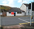
Former cafe to let, Llwynypia
Located opposite Partridge Square post office. http://www.geograph.org.uk/photo/2791425
Despite signs on the building stating "Cafe Open" and "Breakfast served all day",
the premises are empty and the door is locked, with a To Let sign above it.
Image: © Jaggery
Taken: 28 Oct 2011
0.09 miles
9
Partridge Square post office, Llwynypia
The post office is located opposite crossroads, at the meeting of Princess Louise Road, Partridge Road (north and south sections) and Williams Street.
Image: © Jaggery
Taken: 28 Oct 2011
0.09 miles
10
Distances from Llwynypia
The sign at the edge of a major junction shows 6 (miles) to Pontypridd,
3 to Porth as well as other locations via the A4058.
Confusingly, the sign on the left side of the traffic lights also
shows the A4058, but it is pointing to the B4278 towards Trealaw.
Image: © Jaggery
Taken: 30 Mar 2015
0.09 miles


