IMAGES TAKEN NEAR TO
Ynyscynon Road, TONYPANDY, CF40 2LJ
Introduction
This page details the photographs taken nearby to Ynyscynon Road, CF40 2LJ by members of the Geograph project.
The Geograph project started in 2005 with the aim of publishing, organising and preserving representative images for every square kilometre of Great Britain, Ireland and the Isle of Man.

There are currently over 7.5m images from over14,400 individuals and you can help contribute to the project by visiting https://www.geograph.org.uk
Image Map
Images are licensed for reuse under creativecommons.org/licenses/by-sa/2.0
Notes
- Clicking on the map will re-center to the selected point.
- The higher the marker number, the further away the image location is from the centre of the postcode.
Image Listing (26 Images Found)
Images are licensed for reuse under creativecommons.org/licenses/by-sa/2.0
Image
Details
Distance
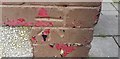
1
Ordnance Survey Cut Mark
This OS cut mark can be found on No102 Ynyscynon Road. It marks a point 148.813m above mean sea level.
Image: © Adrian Dust
Taken: 13 May 2017
0.07 miles
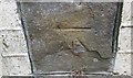
2
Ordnance Survey Cut Mark
This OS cut mark can be found on No 60 Ynyscynon Road. It marks a point 146.795m above mean sea level.
Image: © Adrian Dust
Taken: 13 May 2017
0.08 miles
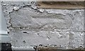
3
Ordnance Survey Cut Mark
This OS cut mark can be found on No213 Trealaw Road. It marks a point 414.385m above mean sea level.
Image: © Adrian Dust
Taken: 13 May 2017
0.13 miles
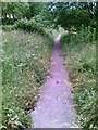
5
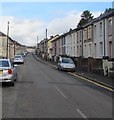
North along Trealaw Road, Trealaw
Towards Ynyscynon Road and Llwynypia.
Image: © Jaggery
Taken: 28 Sep 2017
0.16 miles
6
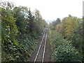
Rhondda Line railway line heads due south, Llwynypia
Viewed from the A4058 road bridge. Llwynypia station is immediately behind the bridge.
The next station is this direction is Tonypandy, about a mile (1.6km) away.
Image: © Jaggery
Taken: 28 Oct 2011
0.16 miles
7
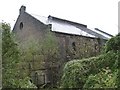
Tonypandy Powerhouse
Built in 1905, the Tonypandy Powerhouse became the engine house of the Llwynypia pit, and five years later became the starting point of the Tonypandy riots.
It was damaged during those riots after lock-out notices were issued to miners after they refused pay cuts in August of that year. Three months later an official strike began by all those employed by the Cambrian Combine.
The riots broke out in the area of the Powerhouse and windows were smashed. There was also rioting in Dunraven Street and Pandy Square in Tonypandy on the same day.
By 7 November, work at all the Cambrian Combine collieries had stopped, with the exception of the Llwynypia pit.
Image: © Kev Griffin
Taken: 15 Nov 2004
0.17 miles
8
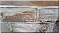
Ordnance Survey Cut Mark
This OS cut mark can be found on No41 Ynyscynon Road. It marks a point 145.076m above mean sea level.
Image: © Adrian Dust
Taken: 13 May 2017
0.17 miles
9
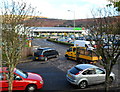
Asda, Llwynypia
The supermarket, opened in November 2007, is located between the A4058 (Llwynypia Road) and the Merthyr Line railway.
Image: © Jaggery
Taken: 28 Oct 2011
0.19 miles
10
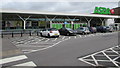
Asda Tonypandy superstore in Llwynypia
Nominally Asda Tonypandy, the superstore is set back from the east
side of the A4058 Llwynypia Road in Llwynypia north of Tonypandy.
Image: © Jaggery
Taken: 2 Oct 2017
0.19 miles