1
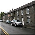
Houses on the east side of Gilmour Street, Tonypandy
Looking north from the corner of Church Street.
Image: © Jaggery
Taken: 21 Sep 2017
0.01 miles
2
Anderson Terrace, Tonypandy
A row of four houses on the north side of St Andrew's Church.
Image: © Jaggery
Taken: 21 Sep 2017
0.03 miles
3
St Andrew's Court, Tonypandy
The Church Street side of flats on the corner of Gilmour Street.
Image: © Jaggery
Taken: 21 Sep 2017
0.03 miles
4
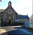
Bethania Welsh Calvinistic Methodist chapel, Church Street, Tonypandy
The Welsh in the name refers to the language used for religious services.
The stone inscription on the facade, and the church board, are in Welsh only.
The year 1908 is inscribed on the building. This was the year that the
original chapel of 1875 was rebuilt or extended. Grade II listed in 1991.
Image: © Jaggery
Taken: 21 Sep 2017
0.04 miles
5
Trottsco office, De Winton Fields, Tonypandy
Roofing and scaffolding business.
Image: © Jaggery
Taken: 21 Sep 2017
0.04 miles
6
Anderson Terrace, Tonypandy
A row of four houses located about 60 metres west of the Rhondda Fawr river.
Image: © Jaggery
Taken: 28 Oct 2011
0.04 miles
7
Cambrian Roofing Ltd, Tonypandy
Located on the west bank of the Rhondda Fawr river, opposite Anderson Terrace. http://www.geograph.org.uk/photo/2675130
Image: © Jaggery
Taken: 28 Oct 2011
0.04 miles
8
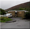
Tonypandy Health Centre
Located at De Winton Field, on the west bank of the Rhondda Fawr river.
Image: © Jaggery
Taken: 28 Oct 2011
0.04 miles
9
St Andrew's Church, Tonypandy
Located at the eastern end of Church Street. St Andrew's is a Church in Wales church in the parish of Tonypandy, diocese of Llandaff.
Image: © Jaggery
Taken: 28 Oct 2011
0.04 miles
10
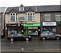
Pooch Palace, Llwynypia Road, Tonypandy
The dog grooming salon is flanked by Get Connected mobile phone shop
and Switch Express electronic cigarette shop. A Get Connected car is on the right.
Image: © Jaggery
Taken: 21 Sep 2017
0.05 miles


