IMAGES TAKEN NEAR TO
Llwynypia Road, TONYPANDY, CF40 2JQ
Introduction
This page details the photographs taken nearby to Llwynypia Road, CF40 2JQ by members of the Geograph project.
The Geograph project started in 2005 with the aim of publishing, organising and preserving representative images for every square kilometre of Great Britain, Ireland and the Isle of Man.

There are currently over 7.5m images from over14,400 individuals and you can help contribute to the project by visiting https://www.geograph.org.uk
Image Map
Images are licensed for reuse under creativecommons.org/licenses/by-sa/2.0
Notes
- Clicking on the map will re-center to the selected point.
- The higher the marker number, the further away the image location is from the centre of the postcode.
Image Listing (87 Images Found)
Images are licensed for reuse under creativecommons.org/licenses/by-sa/2.0
Image
Details
Distance
1
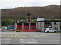
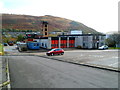
Tonypandy Fire and Rescue Station
Part of the South Wales Fire and Rescue Service, Tonypandy Fire and Rescue Station is set back from the east side of the A4058 Llwynypia Road. The Station serves the town of Tonypandy in the Rhondda Fawr Valley and thirteen other communities including Pentre, Trebanog and Penrhiwfer. The population of the Station area is c51,000. The Station also provides secondary fire cover to the retained Station areas of Treorchy, Porth, Gilfach Goch and Ferndale.
Image: © Jaggery
Taken: 2 Oct 2017
0.00 miles
2
Tonypandy Fire Station
Tonypandy Fire Station, Llwynypia Road, Tonypandy, South Wales
Image: © Kevin Hale
Taken: 5 Jun 2007
0.01 miles
3
Rhondda Sea Cadet Unit, Llwynypia
Viewed across the A4058 Llwynypia Road.
Image: © Jaggery
Taken: 2 Oct 2017
0.03 miles
4
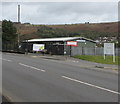
Rhondda Sea Cadets Corps compound, Llwynypia
The representation of anchors on the gates and the mast in the background are clues that the compound has a maritime connection. It is T.S. Minerva No. 485, http://www.geograph.org.uk/photo/2790919 used by Sea Cadets.
Image: © Jaggery
Taken: 28 Oct 2011
0.03 miles
5
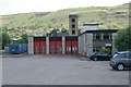
Tonypandy Fire Station
Viewed from Llwynypia Road, Llwynypia.
Part of the South Wales Fire and Rescue Service, Tonypandy Fire Station serves a part of the Rhondda Fawr Valley with an estimated population of 51,000. In addition to Tonypandy, locations covered include Pentre, Trebanog and Penrhiwfer. The station provides secondary fire cover to the retained station areas of Treorchy, Porth, Gilfach Goch and Ferndale. The station's responsibilities also cover large areas of densely planted forest, grass land and heath land.
Image: © Jaggery
Taken: 28 Oct 2011
0.03 miles
6
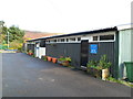
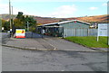
Rhondda Sea Cadets Corps, Llwynypia
Viewed through the railings of a locked, fenced-off enclosure alongside Llwynypia Road (A4058).
The white-on-blue notice next to the door shows
RHONDDA SEA CADET CORPS
T.S. MINERVA
No. 485
PARADE NIGHTS
TUESDAY & FRIDAY
19.00 hrs - 21.30 hrs
NEW RECRUITS WELCOME
T.S. is short for Training Ship, the name used for any Sea Cadets' unit.
The Sea Cadet Corps is a nationwide voluntary uniformed youth organisation, open to all young people aged 12 to 18. The remit of the Sea Cadets is to provide fun, friendship, adventure while learning new skills based on waterborne and land-based activities.
Image: © Jaggery
Taken: 28 Oct 2011
0.04 miles
7
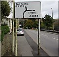
Directions sign, Llwynypia Road, Llwynypia
Facing northbound traffic on the A4058 Llwynypia Road.
Stay on the A4058 for Treorci (Treorchy in English) or take the B4223 for Ton Pentre.
Image: © Jaggery
Taken: 2 Oct 2017
0.04 miles
8
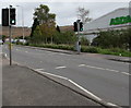
Pelican crossing, Llwynypia Road, Llwynypia
Across the A4058 Llwynypia Road. Chambers Dictionary states that pelican in this context is adapted from "pedestrian light controlled crossing".
Image: © Jaggery
Taken: 2 Oct 2017
0.05 miles
9
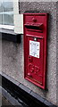
King George V postbox in a Llwynypia Road wall, Llwynypia
On the right here. http://www.geograph.org.uk/photo/2790947
Image: © Jaggery
Taken: 2 Oct 2017
0.05 miles
10
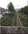
Rhondda Line railway south from Llwynypia
Viewed from Salem Terrace bridge. http://www.geograph.org.uk/photo/5558116
The next station ahead is Tonypandy.
Llwynypia station is below the opposite side of the bridge.
Image: © Jaggery
Taken: 2 Oct 2017
0.05 miles